Overview
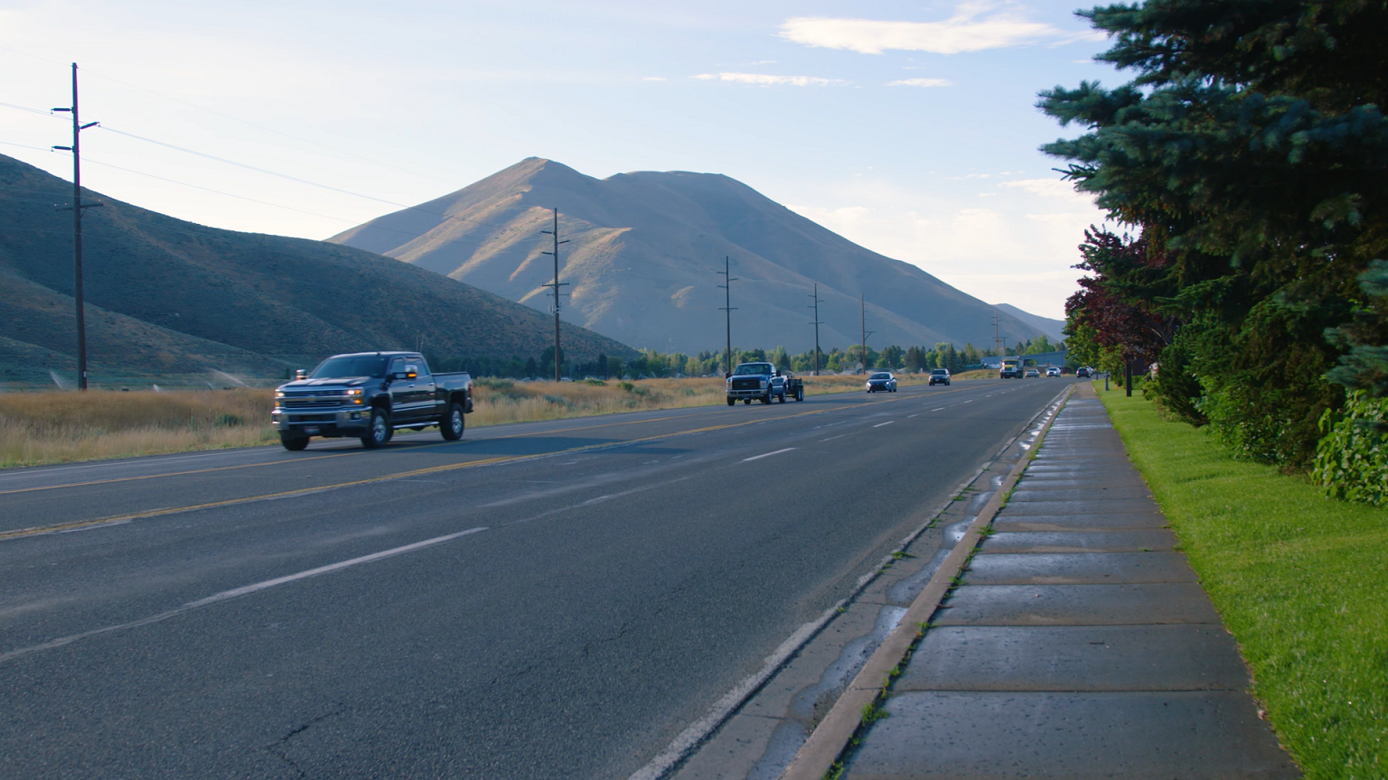
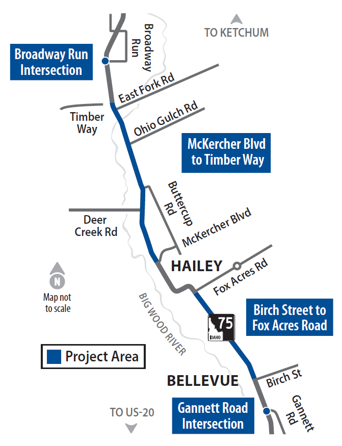
The Idaho Transportation Department has made plans to improve several areas of State Highway 75 between Gannett Road in Bellevue and Broadway Run south of Ketchum
Project Scope
This project includes the environmental and roadway design work that will be necessary to:
- Widen SH-75 between McKercher Boulevard and Timber Way, and between Birch Street and Fox Acres Road. Plans include center medians, wider shoulders and center turn lanes along SH-75.
- Improve several intersections along SH-75.
- Add multimodal infrastructure for pedestrians, cyclists and transit users.
Improvements between Bellevue and Broadway Run are part of ITD’s long-term vision for SH-75. This vision was documented in the 2008 SH-75 Timmerman to Ketchum Environmental Impact Statement. ITD is reevaluating the 2008 EIS to determine if corridor conditions, environmental impacts, or other factors have changed that would affect the design of the project.
ITD is using updated traffic projections, safety data and design plans to determine if the project is still consistent with what was previously approved.
Purpose and Need
The purpose of the project, as stated in the 2008 SH-75 Timmerman to Ketchum Environmental Impact Statement, is to increase SH-75 roadway capacity to accommodate existing peak-hour vehicle traffic and future year 2050 vehicle traffic and to increase transportation safety for all users. The roadway design will be based on year 2050 vehicle traffic.
The need for the project is based on the following:
- Current and predicted future year 2050 peak hour travel demand exceeds available transportation capacity.
- Peak hour congestion is primarily from commuters traveling within project limits.
- Lack of shoulders, right-turn lanes, and center left-turn lanes at intersections creates a safety and capacity concerns throughout the SH-75 corridor.
- Pedestrians and bicyclists currently have limited safe access across SH-75 to community resources.
- Current bus transit and rideshare programs experience peak-hour congestion.
Design Updates
What has changed?
ITD has made several updates to the design plans since the January 2024 Open House. The modifications are based on community feedback and ongoing engineering analysis. The proposed improvements listed below are now progressing into the design stage of the project. Segments that have been modified since the January 2024 Open House are marked with an asterisk, and all changes have been highlighted in orange in the design plans.
Design Plans
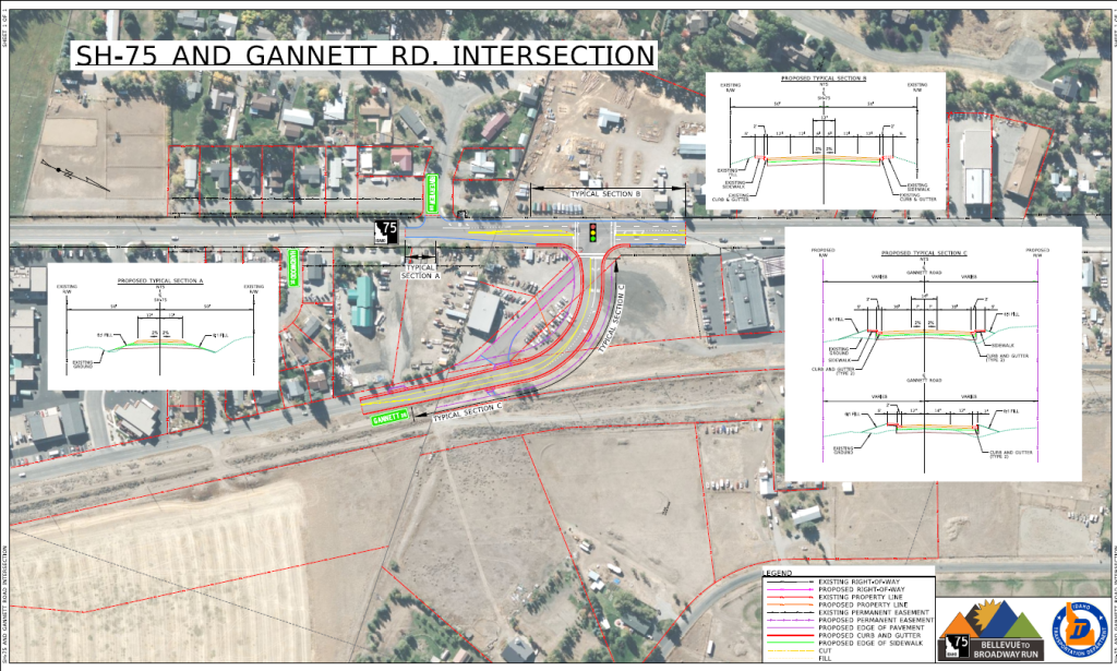
SH-75 and Gannett Road
Proposed Improvements
- Replacing existing curb and gutter and sidewalks within the project area.
- Add sidewalk on Gannett Road.
- Add right-turn lane (for northbound traffic) and left-turn lane (for southbound traffic) at Gannett Road intersection.
- Add 14-foot median on Gannett Road.
- Add right-turn lane into Wood River Meadow Subdivision.
- Add a driveway approach on the west side at Sawtooth Wood Products and close the existing access.

Birch Street to Kirtley Street
Proposed Improvements:
- Widen southbound SH-75 to two lanes between Birch Street and Spruce Street.
- Widen northbound SH-75 to two lanes between Spruce Street and Kirtley Street.
- Add sidewalk connecting current sidewalk between Birch Street and Spruce Street.
- Replace existing sidewalks and pavement.
- Replace existing and extend curb and gutter in both directions.
- Extend sidewalk to Kirtley Street.
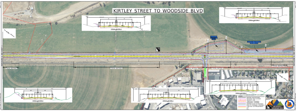
Kirtley Street to Woodside Blvd
Proposed Improvements:
- Widen SH-75 to two lanes in both directions.
- Replace existing pavement
- Replace traffic signal at Woodside Blvd
- Add new curb and gutter on both directions of SH-75
- Add shoulders on both sides of SH-75 north of Kirtley St
- Add a sidewalk and bus stop at the proposed intersection with Malone Development north of Kirtley St
- Extend right-turn lane to Woodside Blvd.
- Add a gravel pad for the Historical Site sign north of Kirtley St.
- Add drainage basin on east side of SH-75, north of Woodside Blvd.
- Remove the median taper on SH-75 between Kirtley St. and Woodside Blvd. and replaced it with a 14-foot center turn lane.
- Remove proposed drainage basin across from Woodside Blvd.
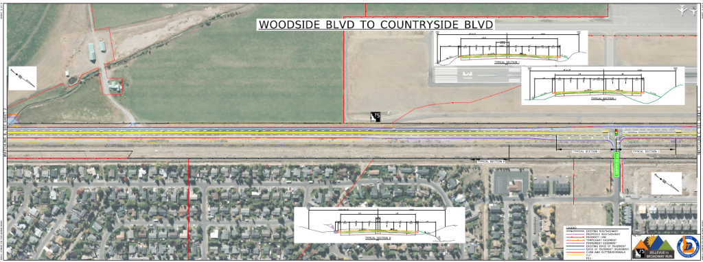
Woodside Blvd to Countryside Blvd
Proposed Improvements:
- Widen SH-75 to two lanes in both directions.
- Replace existing pavement.
- Add new curb and gutter for both directions, except for the south bound lanes adjacent to the airport.
- Extend right-turn lane to Countryside Blvd.
- Replace traffic signal at Countryside Blvd.
- Shift the turning lanes on SH-75 at Woodside Blvd. and Countryside Blvd. intersections 5-feet to the east.
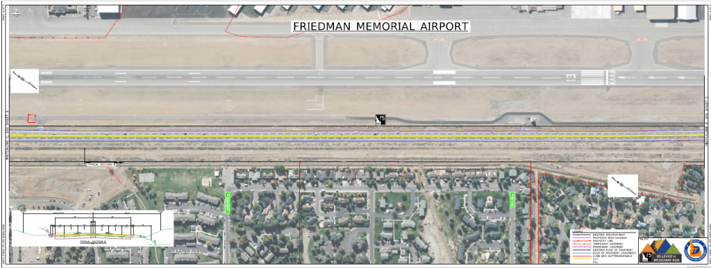
Friedman Memorial Airport
Proposed Improvements:
- Widen SH-75 to two lanes in both directions.
- Replace existing pavement.
- Add new curb and gutter in both directions.
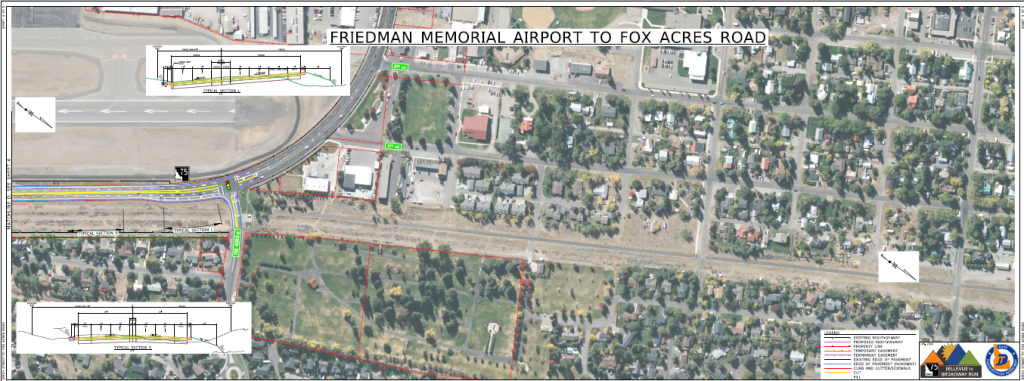
Friedman Memorial Airport to Fox Acres Road
Proposed Improvements:
- Widen SH-75 to two lanes in both directions.
- Add dedicated north bound right-turn lane to Fox Acres Road.
- Replace existing pavement.
- Add new curb and gutter for both directions. Tie into existing curb and gutter.
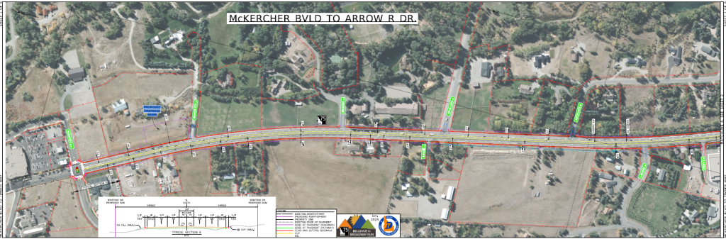
McKercher Blvd to Arrow Dr.
Proposed Improvements:
- Widen SH-75 to five lanes (two lanes in both directions with a center turn lane).
- Modify traffic signal at McKercher Blvd.
- Replace existing pavement.
- Replace existing curb and gutter.
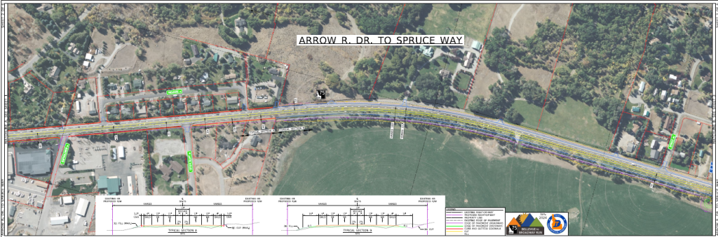
Arrow Dr. to Spruce Way
Proposed Improvements:
- Widen SH-75 to five lanes (two lanes in both directions with a center turn lane).
- Replace existing pavement.
- Replace existing curb and gutter.
- Construct barrier to protect Idaho Power infrastructure.
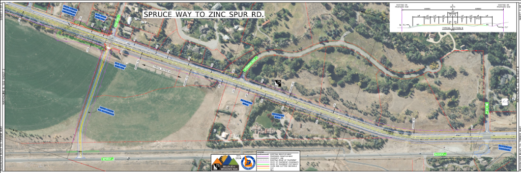
Spruce Way to Zinc Spur
Proposed Improvements:
- Widen SH-75 to five lanes (two lanes in both directions with a left turn lane at Zinc Spur and Ohio Gulch Road only).
- Replace existing pavement.
- Modify the Buttercup Road connection to SH-75.
- Remove Deer Creek Road extension.
- Remove pedestrian underpass at Deer Creek Road.
- Remove bus pullout at Deer Creek Road.
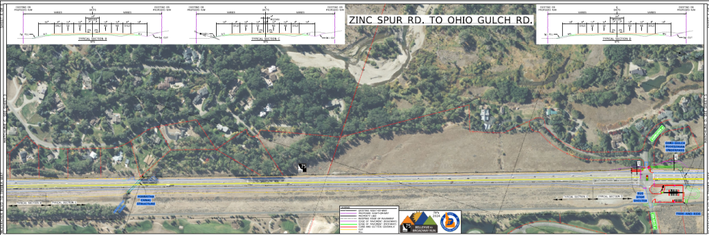
Zinc Spur to Ohio Gulch Road
Proposed Improvements:
- Widen SH-75 to five lanes (two lanes in both directions with a left turn lane at Zinc Spur and Ohio Gulch Road only).
- Replace existing pavement.
- Modify traffic signal at Ohio Gulch Road.
- Add a bus pullouts at Ohio Gulch Road (northbound and southbound SH-75).
- Add a park-and-ride station on the east side of SH-75 at Ohio Gulch Road/Starweather Drive.
- Add a pedestrian underpass at Ohio Gulch Road/Starweather Drive.
- Move southbound bus pullout to northwest corner of Starweather Drive
- Replace and lengthen the irrigation structure at the Hiawatha Canal crossing.
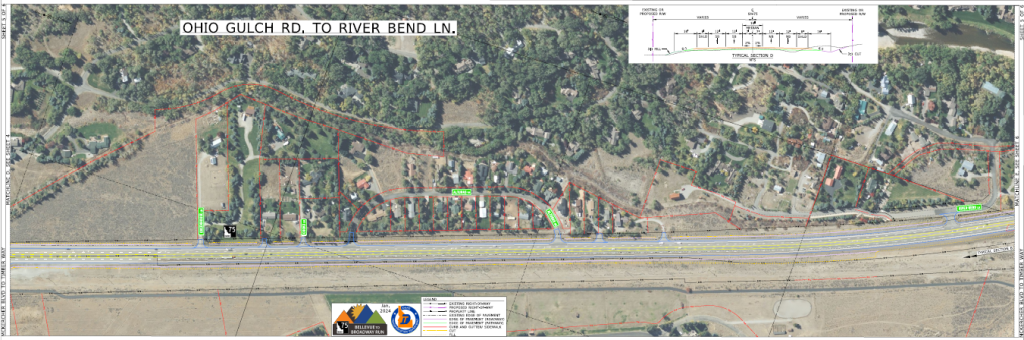
Ohio Gulch Road to River Bend Lane
Proposed Improvements:
- Widen SH-75 to five lanes (two lanes in both directions with a center turn lane). Center turn lane ends between Ohio Gulch Rd and Big Wood River.
- Replace existing pavement.
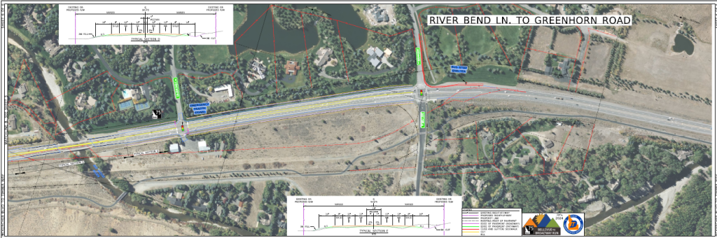
River Bend Lane to Greenhorn Road/East Fork Road
Proposed Improvements:
- Widen SH-75 to five lanes (two lanes in both directions with a center turn lane, except across the Big Wood River bridge).
- Replace existing pavement.
- Add an emergency signal at Fire Station Lane.
- Relocate bus pullout on southbound SH-75 at East Fork Road to northwest corner.
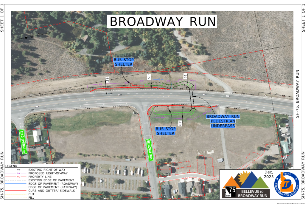
SH-75 and Broadway Run Intersection
Proposed Improvements:
- Construct pedestrian underpass.
- Construct bus pullout on the northbound and southbound sides of SH-75.
Stakeholder Involvement
Stakeholder and community involvement is important to ITD and the success of the project. ITD will continue to provide multiple opportunities for community members to provide input during the environmental reevaluation process. Stakeholder engagement opportunities include:
- One-on-one and small group stakeholder meetings
- Public meetings in November 2022 and January 2024
- Information tables at community events
Frequently Asked Questions
- Current and predicted future year 2050 peak hour travel demand exceeds available transportation capacity.
- Peak hour congestion is primarily from commuters traveling within project limits.
- Lack of shoulders, right-turn lanes, and center left-turn lanes at intersections creates a safety and capacity concern throughout the SH-75 corridor.
- Pedestrians and bicyclists currently do not have safe access across SH-75 to community resources.
- Current bus transit and rideshare programs experience peak-hour congestion.
Visit itdprojects.idaho.gov/pages/sh75bellevue and scroll down to “Downloads and Resources• to download a copy of the 2008 Final Environmental Impact Statement and other materials.
ITD is reevaluating the 2008 SH-75 Timmerman to Ketchum Environmental Impact Statement to determine if corridor conditions, environmental impacts, or other factors have changed that would affect the design of the project. ITD is using updated traffic projections, safety data, design plans and community input to determine if the project is still consistent with what was previously approved.
- Pedestrian underpasses near the Ohio Gulch Road/Starweather Drive and Broadway Run intersections.
- Bus pullouts at the Ohio Gulch/Starweather Drive and Broadway Run intersections and a bus pull out southbound, north of Kirtley Street. ITD will also relocate the southbound bus pull out at East Fork Road (from south of the intersection to north of the intersection) to improve the safety of passengers getting off the bus. The relocation of the transit stop will also make it easier for buses to pull back into traffic on SH-75.
- A Park and Ride lot on the northbound side of SH-75 at Ohio Gulch Road/Starweather Drive. This location will accommodate a future bus charging station.
- Pathways that connect the pedestrian underpasses to the Big Wood River Trail from Bellevue to Ketchum.
Per the 2008 EIS Record of Decision, ITD’s commitment is to continue working with Blaine County and the local communities for future consideration of HOV operations.
- The need to close and relocate many accesses (driveways and approaches) to SH-75 to ensure fewer gaps in fencing where animals could get through.
- The impending development of food sources (e.g., Peregrine Ranch and others) that will attract fewer animals.
- The limited availability of suitable land for constructing a wildlife overpass.
Timeline
-
2022
- Collected traffic data
- Hosted stakeholder meetings and a public meeting
-
2023
- Develop preliminary designs
- Environmental Reevaluation Document
-
2024
- Hosted a public meeting
- Began right-of-way purchases
-
2025-2026
Final design plans are being completed
-
2027
Construction may begin as early as 2027