
Overview
The Idaho Transportation Department, the Community Planning Organization of Southwest Idaho (COMPASS), and member agencies of COMPASS as well as affected highway districts and cities are conducting the South Ada and Canyon County Connectivity Study to evaluate long-term transportation needs south of Interstate 84 in Ada and Canyon counties.
The study was initiated in response to growing traffic volumes, increasing congestion on State Highway 69 and projected growth in Kuna and the southern portions of Boise and Nampa. Today, the roadway network south of I-84 in this area is fragmented and lacks future capacity and connectivity. This study will help evaluate how the regional roadway system may function as growth continues through 2055.
The results will support future planning efforts by ITD, COMPASS and partner agencies. The study does not authorize construction of any specific project.
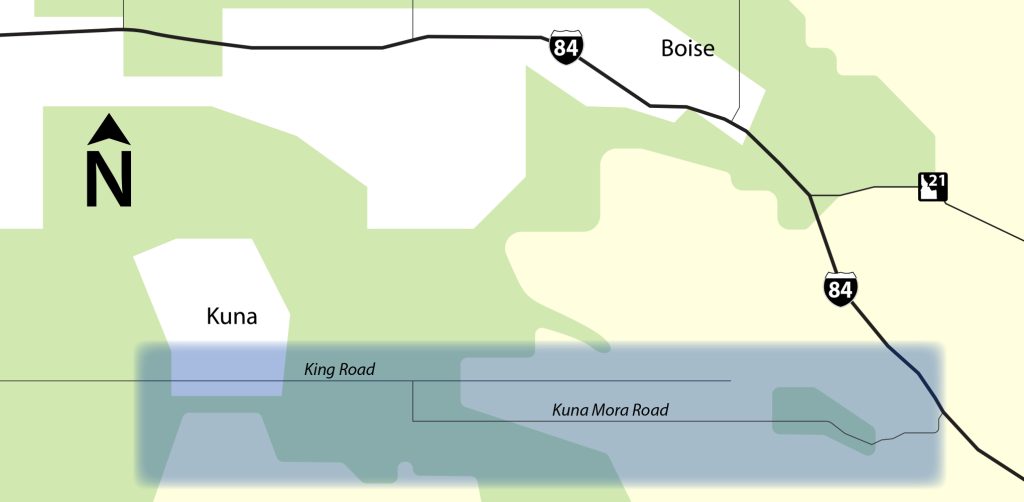
Study Area
The study area extends:
• From State Highway 45 on the west to I-84 near the Blacks Creek Interchange on the east
• From I-84 on the north to approximately two miles south of Kuna-Mora Road
Key roadways within the study area include SH-69, SH-45, I-84, SH-16 and Kuna-Mora Road.
What the Study Is Evaluating
The study is evaluating potential options to improve transportation circulation and capacity in the region. This includes:
• A potential extension of SH-16 south
• A potential extension of SH-69 (Meridian Road)
• Necessary supporting improvements on the local network, including north-south connections such as Cole Road, Five Mile Road, Cloverdale and an alignment that may connect at or near SH-16
• Viability and necessity of a southern arterial roadway on or near Kuna-Mora Road
To evaluate these potential options, the first phase of the study will develop and analyze scenarios by modifying or adding roadway connections and adjusting land use assumptions to reflect expected growth in housing, businesses, and jobs. These scenarios will help understand how traffic moves through the network at a system level, including general travel patterns and volumes across the region. The study will identify the needed network improvements and general type of corridor that could meet projected 2055 traffic needs, including the number of lanes and accommodation for bicyclists and pedestrians, along with very high-level considerations related to traffic flow and access, such as signalized intersections or interchanges. Multiple scenarios will be evaluated, including various combinations of small- and large-scale improvements across jurisdictions.
Existing and Future Conditions
To understand long-term needs, the study evaluates:
2025 Existing Conditions
This reflects how the roadway system operates today.
2055 No-Build Conditions
This predicts how the roadway system is expected to operate in 2055 if no new major improvements are added beyond projects already planned. This evaluation also reflects land use planning, which is managed by cities and counties, not ITD. The no-build scenario establishes a baseline. Future potential scenarios will be compared against it to understand how different options may perform.
2055 Build Scenarios
This evaluates potential alternative routes and network improvements that could support projected growth. These alternatives consider combinations of new and improved corridors to understand how the system may perform under future conditions.
Considerations
The study will consider a range of transportation factors, which may include:
• Level of service (a measure of roadway performance and congestion)
• Volume-to-capacity ratios (amount of traffic on a road compared to the maximum it can handle)
• Travel time
• Changes in traffic volumes
• Congested vehicle miles traveled (total distance driven by vehicles in congested conditions)
Infrastructure needs for new roadway facilities will also be considered at a high level to compare relative cost and complexity between scenarios.
How This Study Fits with Other Plans
The vast majority of public road miles in Idaho are maintained by local highway jurisdictions and cities, including those outside Ada County. ITD manages the state highway system, which includes all interstates, U.S. highways and State of Idaho highways. While this system represents a smaller share of total road miles, it carries a significant portion of daily traffic, serving both local trips and regional travel, as well as key routes for commerce.
The Treasure Valley’s transportation network is made up of many connected parts managed by multiple partners. The state highway system serves as the backbone that connects local systems across jurisdictions. This study looks at the network as a whole and incorporates the needs of travelers and planning partners to explore solutions for congestion that crosses jurisdictional boundaries.
This study reviews and incorporates relevant local and regional plans, including Communities in Motion 2050 and other corridor studies. Many regionally significant projects are already included in the regional modeling used for evaluation.
What This Study Does and Does Not Do
This study:
• Evaluates long-term transportation needs
• Identifies potential corridor concepts and appropriate facility types (such as arterial, expressway or freeway) based on projected traffic volumes and travel patterns
• Considers general characteristics such as desired operating speeds and level of service
• Updates the regional travel demand model to provide a data-driven baseline for comparison
This study does not:
• Commit funding to any specific project
• Approve construction of a corridor
• Override local land-use authority
• Identify any specific location for future state highways
Future decisions will occur through separate planning, environmental and design – all requiring additional funding.
Next Steps
The findings from the existing and future no-build evaluation will identify proposed improvements to potential roadway network and land-use scenarios. Those improvements will be evaluated in later stages of the study.
Results from the initial evaluation are anticipated in 2026.