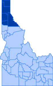
I-90 paving project begins next week from Wolf Lodge over Fourth of July Pass

Aerial view of Interstate 90 at the top of Fourth of July Pass


Starting next week, the Idaho Transportation Department will begin to resurface an 8-mile stretch of Interstate 90 to preserve and extend the life of the roadway, enhance safety, and deliver a smooth ride for travelers. This will be a two-year project, ending in fall of 2026.

This project will also add illumination near the top of Fourth of July Pass, improve the highway drainage system and replace several miles of concrete barrier.

Work on both eastbound and westbound lanes of traffic will occur simultaneously in small, continuous sections of the 8-mile work zone. There is a scheduled break in construction over winter between the 2025 and 2026 construction seasons, but if mild winter weather prevails, some work may continue to advance the project ahead of schedule.

TRAFFIC IMPACTS

  • Lane reductions
  • Speed reductions
  • Lane width restrictions
  • Intermittent flagging possible

During construction, drivers can expect traffic to be reduced to a single lane in each direction with reduced speed limits and lane width restrictions. Intermittent flagging may also be necessary at on- and off-ramp locations.

Work will be conducted during daytime hours; however, lane and speed restrictions will remain in effect at all times through the construction season.

This project is one of several that will dot the I-90 corridor from the Washington state line to the Silver Valley in 2025, including the I-90 expansion project between Post Falls and Coeur d’Alene, the I-90 State Highway 41 Interchange project, and the I-90 bridge replacement project near Cataldo.

To assist motorists with safely and effectively navigating the North Idaho interstate system, ITD hosts the Idaho 511 system that is available online, by phone, or by downloading the Idaho 511 app to any smart device. This system allows users to subscribe to notifications along specific routes that will help them stay updated on changing conditions and plan ahead for potential delays. Drivers are strongly encouraged to use this free resource.


SH-54 right of way closure to motorized and non-motorized use ahead of highway expansion project

Aerial view of SH-54 and the adjacent ORV trail


With tree removal and utility relocation mostly complete, construction is set to begin on the stretch of highway from State Highway 41 to Greystone Road near Athol.

Starting next week the right of way along the south side of SH-54 – including the unofficial off-road trails – will be closed to all traffic due to the active work zone with heavy equipment. This closure is necessary to ensure the safety of everyone, including those using the trails, construction crews, and others on the adjacent roadway.


Why is the right of way area closing?
The first phase of highway expansion, which will occur from early spring through mid summer, will focus primarily on the south side of the highway. Significant demolition and construction will take place in the right of way area adjacent to the roadway, including excavation, ditching, and paving. This work will involve heavy equipment and work crews, making the area unpredictable and, more importantly, unsafe for any kind of traffic – both motorized and non-motorized. This includes motorcycles, ATV’s, side by sides, bikes, pedestrians, and equestrian riders.

We understand that these closures may cause frustration, especially for those who have come to rely on the trail as a secondary route of travel. The main concern, however, is safety.

Who will be affected?

All trail users will be affected by this closure, but with the proximity of both Timberlake High School and Middle School, it’s important for parents to understand this route will also not be accessible for students, teens or underage drivers who use the trail to get themselves back and forth to the schools or to their extracurricular activities.


What does this mean for off-road vehicle traffic?
Since the unpaved right of way area along SH-54 will be closed during construction, it will not be acceptable for any un-registered off-road vehicles or unlicensed drivers to use the state highway as an alternative route. Highway traffic is governed by strict regulations, and the presence of off-road vehicles or unlicensed drivers would pose serious safety risks to both those operating ORVs and other road users. Off-road vehicles cannot legally operate on public highways unless appropriately registered and licensed for street use.

To ensure everyone’s safety, all ORV users will need to plan alternative routes or transportation, and we ask that young, unlicensed drivers in particular, avoid using the highway as a shortcut.

We are committed to working together with the community to help navigate through this closure as safely as possible.

This project is essential for improving safety and infrastructure for everyone, including the students and families who use the highway every day.  We appreciate your patience as the project moves forward and we will continue to provide updates on any other developments that may affect the community.


Will there be room for a new trail in the right of way after the project is complete?

No. Once the highway expansion project is completed in 2026, the entire width of the right of way will be dedicated to shoulder space and sloping to meet modern roadway engineering standards. This space is necessary to improve traffic flow and ensure the highway complies with current standards and practices that prioritize the safety of users. As a result, there will not be room for an off-road vehicle trail or shared use path in the right of way.

The expanded roadway is designed to accommodate future growth and to provide a safer, more efficient route for everyone. While this change may limit access to the area for off-road vehicles, the improvements will help reduce traffic hazards and provide a safer environment for all road users, including pedestrians and cyclists, by including 6 foot shoulders.

We encourage the community to explore alternative areas specifically designated for off-road use for recreation.

New lane at busy SH-53 intersection in Rathdrum to ease congestion

Traffic backed up at the intersection with cones

Starting next week crews will return to Rathdrum to begin construction on State Highway 53 near the State Highway 41 intersection north of the railroad tracks.

The Idaho Transportation Department will construct an additional northbound through lane on SH-53 so that two lanes of traffic are able to move north through the intersection during green cycles. After construction SH-53 will still have a dedicated right turn lane for vehicles wishing to travel over the bridge.

The additional lane is intended to allow for more vehicles at a time to make it through the signal and help reduce the length of queued vehicles during peak hours.

During construction crews will close the existing right turn lane, meaning all northbound SH-53 traffic will make all movements from the one through lane. Drivers should also expect reduced speed limits and flagging. Any flagging for signal work will be done outside of peak hours.

Updates to traffic impacts and delays can be found using the Idaho 511 system either online, by phone or through the app.

Public invited to review proposed design for I-90, US-95 Interchange

I-90 US-95 Open House Invitation

 
The Idaho Transportation Department will host an open house next week in Coeur d’Alene to share information and gather input on the proposed redesign of the Interstate 90 and U.S. Highway 95 Interchange and associated local road improvements.
 

Date: Wednesday, March 5

Time: 4 p.m. – 7 p.m. (drop in anytime)

Location: Best Western Plus Coeur d’Alene Inn

506 West Appleway Avenue, Coeur d’Alene, ID 83814
 

The design is funded by Governor Little’s Leading Idaho initiative and is the first interchange project to emerge from the I-90 Corridor Study. The goal of the proposed design is to expand the interchange, enhance safety, and improve mobility to support future traffic volumes, which are expected to double by 2045. Ideas regarding the design for a future new interchange for I-90 and US-95 have been presented to the public through open house events of the past in 2022 and 2023.
 

The current design proposes several improvements, including a new single-point urban interchange, widening US-95, and grade separating US-95 and Appleway, among others.
 

For those not able to attend the open house in person, an online option will share the same information and be available starting March 5 at itdprojects.org/i90corridor. Comments submitted online before March 19 will be considered by the project team.
 

“The I-90 and US-95 Interchange connects two of the most traveled, and most congested, roadways in the region. Adding capacity and improving mobility on the interchange and adjacent roads will help to alleviate congestion, reduce crashes, and shorten commutes,” ITD Project Manager Joey Sprague said. “The intersection at US-95 and Appleway has the most crashes of any intersection in North Idaho. The proposed design will increase both vehicular and pedestrian safety and optimize interchange operations for decades to come.”
 

ITD is meeting with city officials, property owners and local businesses ahead of the public open house to present the design, answer questions and gather feedback. To stay up to date on this and other projects on the I-90 corridor, visit itdprojects.org/i90corridor and sign up for email updates.

Spring road restrictions go into effect on Idaho roadways

Sign notifying drivers of breakup limits in effect.


Sections of some state highways in Boundary County will find themselves under weight and speed restrictions starting at 6 a.m. tomorrow as regional weather trends begin to warm ahead of spring.

Immediate impacts to commercial vehicles will be:

US-95 from the US-2 junction to Eastport (milepost 511 to 538.56)

Commercial vehicles 10,000 gross vehicle weight rating and greater will be restricted to 30 miles per hour with legal axle weight

US-2 from the US-95 junction to the Montana state line (milepost 64.35 to 80.18)

Commercial vehicles 10,000 GVWR and greater will be restricted to 30 miles per hour with legal axle weight

SH-1 from the US-95 junction to Porthill (milepost 0 to 11.19)

Commercial vehicles 10,000 GVWR and greater will be restricted to 30 miles per hour and 14,000 LB per axle, or legal axle weight whichever is less

State Highways 200 and 57 in Bonner County will likely also see similar restrictions in place starting next week.

As the season changes, additional sections of highways across the entire Idaho Panhandle may have load limits and speed restrictions in effect. These restrictions are communicated with red/green indicator flags on load limit signs. Red means restrictions are in effect and large vehicles must follow the reduced limits. When green flags are out it means all traffic can flow without restrictions as the road conditions are more stable.

ITD crews closely monitor both weather and road conditions and make determinations about restrictions being in effect, which is why drivers may see them intermittently on and off as conditions change.

“These restrictions are put in place when the highways start showing signs of stress from the winter freeze/thaw cycle,” Boundary Foreman George Shutes said.

As the frost and ice thaw, they turn into water underneath the road, making the ground soft and highly vulnerable to damage. Large vehicles, because of their weight, push that water as they drive, almost like a wave moving through the layers beneath the road. This causes serious damage to the highway’s base and pavement, leading to cracks, erosion, and ultimately, the road breaking down much faster.

Slowing those vehicles down, and in some cases, limiting the weight, significantly reduces the stress on the roadway and prevents unnecessary damage like severe potholes. This not only protects the road from costly repairs, but also extends its lifespan, ultimately saving taxpayer dollars and ensuring safer driving conditions for everyone.

While restrictions are in effect, state law does not require large vehicles to pull over or allow cars to pass. This means that there is the potential for delays with reduced speeds along highway corridors.

“The best thing people can do this time of year is give themselves a little extra time to get from point A to point B,” Idaho State Police Sergeant Ron Sutton said. “Too often we see people get impatient and take unnecessary risks, like attempting to pass when it’s not safe, and those decisions can lead to disaster.”

Load limit restriction information is largely targeted towards commercial drivers on the 511 system, however that information is available to everyone by adjusting program settings. Drivers can find up to the minute road restriction information both online and through the app by following the steps below.

Online users can select the ‘Restrictions’ option under ‘Trucker Information’ on the menu on the right side of the page. See the first example below.

Mobile users can select the driver view setting to toggle into ‘Trucker view’ mode to view restriction information.  See the second example below.

Example 1

Example 2

ITD announces new incident response program for the I-90 corridor in North Idaho

ITD's new Incident Response Vehicle

UPDATE: This service will now be on duty Monday – Thursday, 6 a.m. to 4:30 p.m., after further coordination with law enforcement. 

The Idaho Transportation Department is excited to announce the launch of a brand-new Incident Response Vehicle program, which will begin operation next week to assist drivers along key corridors in North Idaho. This initiative is designed to enhance safety by providing rapid response to disabled vehicles, minor crashes, and other roadside emergencies, allowing motorists to get safely off the highway with minimal delay or risk to other drivers.

The IVR will primarily patrol the I-90 corridor, focusing particularly on work zones where limited shoulders and a lack of space pose more risk for travelers experiencing difficulties. These high-priority areas include ongoing construction projects at the State Highway 41 Interchange and the upcoming four lane expansion between Post Falls and Coeur d’Alene. Additionally, the truck will respond to incidents along the US-95 corridor stretching from the Spokane River Bridge to Lancaster Road through Coeur d’Alene.

The program will offer a wide range of services to assist drivers in need, including helping with flat tire changes, delivering small amounts of fuel for vehicles that have run out, jump-starting dead batteries, and even providing push or pull assistance for vehicles stuck in ditches following a crash or slide-off. The truck is fully equipped with the tools necessary to address minor maintenance issues and also has lights and signs to alert other drivers to a potential hazard while they work to clear the incident. Outside of keeping everyone safer, these free services are expected to save money by preventing costly congestion.

The new truck will be operated by a dedicated ITD operations employee and will be in service from Tuesday to Friday, between 6 a.m. and 4:30 p.m. The schedule was created based on data analysis of traffic volume and incident trends to maximize the program’s impact during peak hours and will be subject to change with the season.

“We are excited to bring this vital service to North Idaho,” said Ryan Crabtree, ITD Business Operations Manager. “By providing this dedicated vehicle, we are not only helping drivers get back on the road more quickly but also improving safety for everyone by reducing the risks associated with stopped vehicles in high-traffic areas.”

The new program builds on the success of a similar initiative in the Treasure Valley region of Southern Idaho, which has been operational since 1997. In fact, this initial vehicle was donated by ITD’s southern district. District One plans to add an additional incident response truck to its fleet later this summer

This new program also aims to support law enforcement agencies by helping to alleviate some of their non-emergency calls for traffic issues. With the addition of ITD’s Incident Response Truck, local law enforcement can focus on more complex and urgent matters, while ITD staff handle minor incidents and roadside assistance. For more critical traffic incidents that require police investigation, the IRV can help to provide additional traffic control to ensure the safety of first responders and other drivers on the road.

“We look forward to working closely with local law enforcement agencies to ensure a coordinated response to incidents,” Crabtree said. “This collaboration will help ensure that our highways are safer and that we are meeting the needs of the community.”

ITD encourages drivers to slow down and “move over” in accordance with Idaho law when emergency vehicles like this one are operating.

Anyone finding themselves in need of assistance, especially through the work zones or on busy roadways, should report emergencies to 911 or non-emergencies to local law enforcement.

Work on the I-90 bridges near Cataldo will begin to impact traffic

Aerial view of the I-90 bridges over the Coeur d'Alene river near Cataldo

Starting next week drivers will be required to slow down and merge into a single lane in both directions as work resumes to reconstruct the Interstate 90 bridges over the Coeur d’Alene River near Cataldo. These bridges were first built in 1964 and are ready for replacement.

As early as mid-March all traffic will be shifted on to the westbound side of the interstate to allow crews to demolish and reconstruct the eastbound bridge. Next year, the westbound bridge is scheduled for replacement with traffic shifted to the new eastbound bridge. Work will end in late 2026.

River and trail users will also experience impacts during the 2025 construction season.

River Impacts

Beginning April 1 recreational access and use of the river, including boating, kayaking, tubing, swimming and fishing will be restricted for 500 feet on both sides of the bridges Monday through Saturday from 6 a.m. to 6 p.m. Boat launches outside of the work zone will remain available for use, though no one will be able to pass underneath the structure during working hours for safety reasons.

Construction will take scheduled breaks during the major summer holidays and access to the river will be available for recreation.

Signs will be posted locally at boat launches and access points that will update users of restrictions or changes throughout the construction process.

Trail of the Coeur d’Alenes Impacts

During construction trail users should be aware that there may be intermittent closures of five or ten minutes as equipment and materials are transported across the trail during day to day operations. Flaggers will be present during these closures to ensure safe crossing for crew members, vehicles and trail users.

Trail users should exercise caution in areas adjacent to the work zone for the possibility of loose dirt or gravel on the trail surface.

In 2024 a temporary work bridge was constructed across the river to provide crews and equipment access. Crossover lanes were also constructed on both ends of the work zone to allow for vehicles to be shifted during construction to maintain the flow of traffic.

Map depicting the I-90 work zones from Post Falls to Cataldo for the 2025 construction season.


This project is one of several that will dot the I-90 corridor from the Washington state line to the Silver Valley in 2025, including expanding the freeway to four lanes between Post Falls and Coeur d’Alene, upgrading the I-90 State Highway 41 Interchange, and repaving from Wolf Lodge to Fourth of July Pass.

Drivers are encouraged to use the Idaho 511 system, either online, by phone or through the app, for updates on conditions and traffic impacts throughout the construction season.

Significant traffic changes ahead for construction on the I-90, SH-41 Interchange in Post Falls

Aerial view of the westbound I-90 SH-41 exit loop ramp

Starting Monday, March 3, the Idaho Transportation Department will be making several significant changes to traffic near the Interstate 90 and State Highway 41 Interchange. These changes are necessary to accommodate ongoing construction efforts as ITD nears a major milestone of the project with the completion of the new Single Point Urban Interchange.

I-90 westbound off ramp to get to SH-41

  • Closed March 3 through Fall 2025
  • Traffic will be detoured to the Seltice Way Interchange at Exit 6. Click here for detour map.
  • A temporary signal has been installed at Seltice Way to handle detoured traffic exiting the interstate

On ramp from SH-41 to get onto eastbound I-90

  • Closed overnight from 8 p.m. to 5 a.m. from March 3 through mid-March
  • Traffic will be detoured west on Seltice Way to the exit 6 eastbound on-ramp.

SH-41 under I-90                                                                                       

  • Closed March through mid-April
  • Traffic will be diverted to Greensferry Road while crews deconstruct the temporary bridge and work on utilities. Click here for detour map.

Central Avenue                                                                                          

  • Closed early March through Fall 2025
  • Click here for a map of available business accesses.

Overnight single lane closures on I-90 in both eastbound and westbound lanes throughout the work zone

  • 8 p.m. to 5 p.m. March 3 through mid-April

Westbound on ramp for SH-41 traffic


Additional changes to the westbound on-ramp are coming later this spring. Details will be shared as soon as they are available.

“Reconstructing the westbound off-ramp and improving SH-41 is a key part of the project’s success,” said project manager Randy Durland. “We thank the public again for their patience during these closures as crews continue to make significant progress towards the finish line.”

Construction on the new ramp and SPUI is expected to be complete in 2026.

Drivers can use the Idaho 511 system for updated traffic conditions, detours and delays by dialing 511, visiting the website, or downloading the app to your smart device.

To learn more, visit the project website at https://itdprojects.idaho.gov/pages/i90sh41ic, call 208-738-4190, or email info@i90corridor.com.

Pleasant View Road scheduled to close south of SH-53

Looking at SH-53 south with a view of some of the new bridge structures being built.

The Idaho Transportation Department will close Pleasant View Road between State Highway 53 and Prairie Avenue as early as the first week of March. Drivers will be able to use either Prairie Avenue or McGuire Road to access SH-53. This closure is part of the SH-53, Pleasant View Road Interchange construction that started last fall. The project will enhance safety along the highly traveled SH-53 corridor by ultimately eliminating three railroad/vehicle crossings, streamlining access to SH-53, and increasing capacity on SH-53 and Pleasant View Road.

IMMEDIATE IMPACTS

In preparation for the Pleasant View Road closure, barricades will be installed the week of February 17 at the Prairie Avenue and Beck Road intersection to prevent left-turn movements to and from both streets.

  • Northbound drivers on Beck Road will need to turn right on Prairie Avenue and do a full rotation of the roundabout to access SH-53 from westbound Prairie Avenue.
  • Westbound drivers on Prairie Avenue will need to find an alternative route altogether to access southbound Beck Road.

Additionally, ITD is working closely with BNSF Railway to install a temporary signal on SH-53 at Prairie Avenue, which is anticipated to be active sometime in early summer. These restrictions will be in place until the Pleasant View Road Interchange is completed in summer of 2026.

“ITD understands that construction of this new interchange and associated improvements will significantly impact travel patterns for local and regional drivers,” said Project Manager James Dorman. “Safety is a top priority, and the measures taken during construction are done so with this objective in mind. We appreciate everyone’s patience and understanding as we work to increase safety and mobility for people using this corridor.”

The first features to be constructed include the footings for the Pleasant View bridge over the railroad tracks and the new alignment of SH-53 between Hauser Lake and Hollister Hills Roads north of the existing highway. One lane of traffic in each direction will predominantly be maintained on SH-53, and work will typically take place weekdays during daylight hours.

Construction of this project is being made possible now by a U.S. Department of Transportation Federal Railroad Administration grant that was awarded to ITD in mid-2023. The grant program was created to improve safety at rail crossings in communities across the country to save lives, time, and resources for American families. Additional financial contributions were made by ITD’s partnering organizations: BNSF Railway and the Post Falls Highway District. The estimated construction cost of this project is $30 million.

People are encouraged to stay informed by visiting the project website and subscribing to emails at itdprojects.idaho.gov/pages/sh53corridor. For statewide traffic information, and up to the minute information regarding impacts or delays along the SH-53 corridor, visit 511.idaho.gov, dial 511 by phone, or download the app.

Idaho Transportation Board approves funding to study US-95 Long Bridge for replacement

Aerial view of the Long Bridge looking north into Sandpoint


Today the Idaho Transportation Board approved $200,000 to start studying replacement options for the Long Bridge on U.S. Highway 95 near Sandpoint. 

“Up until now, we have been performing maintenance projects to delay replacing this expensive structure until it reached 100 years old,” District Engineer Damon Allen said. “But as we’ve looked to widen US-95 south of town, we’ve heard from the public that they want us to look at this sooner rather than later.”  

The study is expected to start in 2025, with the goal of seeking grant funding to finish the study and design. It would include public outreach and updating environmental evaluations. This would be separate from the ongoing plans to make US-95 safer and capable of handling the increase of traffic between Sagle and Lakeshore Drive, though neither is funded for construction.  

The existing bridges—one for vehicles, and the other for pedestrians—were built in 1981 and 1956 respectively. The pedestrian bridge, which originally served vehicles, is no longer able to safely carry traffic and is severely weight restricted.  

Previous studies have identified one four-lane bridge with shoulders and a separated bike and pedestrian facility to replace the two existing two-lane bridges. Costs and staging would be identified in later studies, but the initial estimate for building the northbound half of the proposed structure, including a bike and pedestrian facility, is at least $225 million.  

“This money will allow staff to begin preliminary planning and pursue grant applications for design,” Allen said.