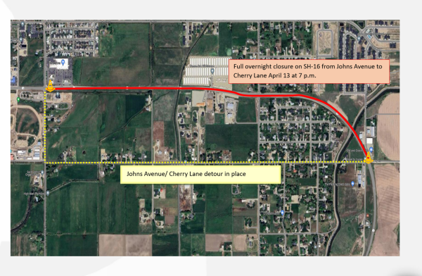
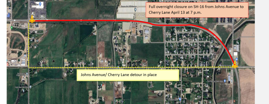
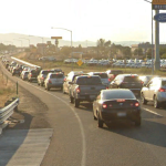
The Idaho Transportation Department will close State Highway 16 between Johns Avenue and Cherry Lane in Emmett this Saturday.
The SH-16 overnight closure will begin at 7 p.m. April 13 and reopen to traffic the following day. The closure is necessary in order to replace an irrigation pipe beneath the highway. Traffic control will be in place with a detour routing traffic onto Johns Avenue and Cherry Lane.
Drivers can utilize the Idaho 511 system by phone, online, or through the app for updated closure information.
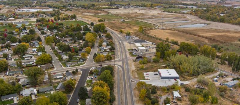
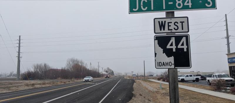
The Idaho Transportation Department (ITD) is hosting two open houses next week to present and gather feedback on alternative alignments for State Highway 44 from Interstate 84 to Star Road. ITD will collect feedback from the public both at the in-person open house and via an online survey.
Details for the open houses are below:
- Wednesday, April 3, at Star Fire Protection District at 11665 W State Street, Ste. B in Star – 4:30 p.m. – 7 p.m. (drop in anytime)
- Thursday, April 4, at Middleton Middle School at 511 W Main Street in Middleton – 4:30 p.m. – 7 p.m. (drop in anytime)
The same information will be available at both in-person open houses. A virtual open house with identical information will also be available from April 3 through April 17 at itdprojects.idaho.gov/pages/sh44pel.
“We encourage everyone to join us at an upcoming open house to share their feedback. Your input is crucial as we make informed decisions to advance this project, meeting both the present needs and future travel demands in this growing area,” Project Manager Mark Wasdahl said.
In this initial study phase, ITD is implementing the Federal Highway Administration’s Planning and Environmental Linkage (PEL) process to identify and screen transportation improvements. Once improvements have been chosen, the project will transition into the National Environmental Policy Act (NEPA) phase.
To learn more about the project and sign up for email updates, please visit itdprojects.idaho.gov/pages/sh44pel.
The Idaho Transportation Department (ITD) is hosting two open houses next week to present and gather feedback on alternative alignments for State Highway 44 from Interstate 84 to Star Road. ITD will collect feedback from the public both at the in-person open house and via an online survey.
Details for the open houses are below:
- Wednesday, April 3, at Star Fire Protection District at 11665 W State Street, Ste. B in Star – 4:30 p.m. – 7 p.m. (drop in anytime)
- Thursday, April 4, at Middleton Middle School at 511 W Main Street in Middleton – 4:30 p.m. – 7 p.m. (drop in anytime)
The same information will be available at both in-person open houses. A virtual open house with identical information will also be available from April 3 through April 17 at: itdprojects.idaho.gov/pages/sh44pel.
“We encourage everyone to join us at an upcoming open house to share their feedback. Your input is crucial as we make informed decisions to advance this project, meeting both the present needs and future travel demands in this growing area,” Project Manager Mark Wasdahl said.
In this initial study phase, ITD is implementing the Federal Highway Administration’s Planning and Environmental Linkage (PEL) process to identify and screen transportation improvements. Once improvements have been chosen, the project will transition into the National Environmental Policy Act (NEPA) phase.
To learn more about the project and sign up for email updates, please visit itdprojects.idaho.gov/pages/sh44pel.
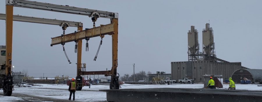
Sixteen, 96-foot girders that weigh 77,963 pounds each will be transported March 13 and 14 to begin building the Interstate 84, State Highway 16 Interchange as part of the Leading Idaho program.
Six bridges along SH-16 are being built with girders made in Caldwell. In total, Contech Engineered Solutions will build 57 girders and the retaining walls for the I-84, SH-16 Interchange. The bridge supports will be used at Ten Mile Creek, McMillan Overpass, Quasi Place, Five Mile Creek, Cherry Lane and I-84.
SH-16 is a testament to the job creation and economic opportunities that come from road construction projects.
Contech employs 52 people at their Caldwell location. The local company says road construction projects like this have a positive effect on many Idaho businesses.
“The materials to make these are local. The bar we buy is from a local supplier. The concrete and aggregate come locally from Idaho. We try to support the local community as much as possible. We are very proud of the work we do here,” Contech Engineered Solutions Sales Manager Lee Wegner said.
The multi-year project encompasses more than four miles of new highway from I-84 to U.S. 20/26 (Chinden Boulevard). Beyond the jobs that come from building a new highway, the project creates better connectivity to Gem County, promising a future of increased accessibility and growth.
This project is funded with Transportation Expansion and Congestion Mitigation (TECM) funds as a part of Governor Little’s Leading Idaho program. This initiative allows ITD to address rapid growth and aging infrastructure in critical corridors throughout the state.
Contech is also constructing girders for the Simco Road Bridge near Mountain Home and the bridge under SH-55 in the Avimor development.
At 10:25 a.m. MST local time, an earthquake measuring 4.9 on the Richter scale occurred just north of Smiths Ferry, prompting an immediate response from the Idaho Transportation Department (ITD). To ensure public safety, ITD is doing a thorough assessment of roads, culverts, and bridges in the affected vicinity.
ITD’s bridge inspectors and maintenance crews will be in the area assessing all bridges and roads, including the most photographed bridge in Idaho, the Rainbow Bridge. While there are currently no indications of damage, there has been some small rockfall on the roadway.
In the event of any damage resulting from the earthquake, ITD will provide prompt notification to the public.
ITD wants to reassure the community that every measure is being taken to assess and address potential safety risks from this earthquake, demonstrating our unwavering dedication to maintaining a secure transportation network for all.
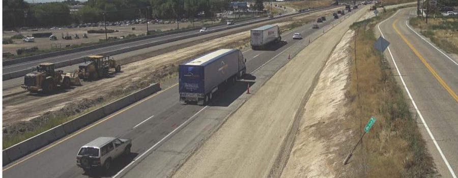
The Idaho Transportation Department (ITD) is beginning construction on the I-84, Karcher Interchange in Nampa on Monday as part of the Leading Idaho program. Improvements will increase safety and mobility at the interchange and along State Highway 55 (SH-55)/ Karcher Road between the westbound ramps and Sundance Road. Construction is expected to be complete in fall 2025.
Motorists will see overnight lane closures on I-84 starting Monday, Feb. 19. Crews will shift traffic to create a work zone and begin building the third lane on the overpass bridge.
During the project, motorists can expect:
- All lanes open during the day.
- I-84 overnight closures for traffic shifts, bridge work and girder placement.
- Major work will take place at night from 10 p.m. to 5 a.m. with one lane open in each direction on Karcher Road.
- Bike lanes and sidewalks in the project area will be detoured.
- Access to local businesses will be open.
- Speed limits will be reduced.
“The Karcher Interchange’s design life has been outpaced by the huge amounts of growth Nampa has seen recently,” Resident Engineer Andrew Linder said. “The work on the interchange will account for this growth by adding capacity and improving safety. ITD is making every effort to minimize impacts to businesses in the area and the traveling public.”
Improvements will include:
- Reconfiguring westbound and eastbound off-ramps to improve safety and traffic flow, and increase capacity.
- Widening the interchange bridge to provide a dedicated lane for the westbound off-ramp traffic to travel westbound on Karcher Road (SH-55).
- Adjusting signals at ramp intersections, Caldwell Blvd and Cassia St.
- Adding a third westbound lane and dedicated right turn lane at the intersection of Karcher Road (SH-55) and Caldwell Boulevard.
- Adding a pedestrian flashing beacon at the I-84 eastbound on-ramp and widening some sidewalks within project limits.
- Repaving Karcher Road (SH-55) from the westbound on-ramps to Middleton Road.
This project is funded with Transportation Expansion and Congestion Mitigation (TECM) funds as a part of Governor Little’s Leading Idaho TECM program. This initiative allows ITD to address rapid growth and aging infrastructure in critical corridors throughout the state.
For more information:
The Idaho Transportation Department is hosting an online public meeting to inform the public about the design of an eastbound auxiliary lane on eastbound Interstate 84 between the Meridian Road and Eagle Road interchanges. This additional lane to enter and exit I-84 will reduce congestion between these interchanges, making it safer for drivers to access the freeway.
The online meeting is available from Feb. 13 through Feb. 28 at itdprojects.idaho.gov/pages/i-84-meridian-interchange-to-eagle.
The online meeting provides the public with an opportunity to learn about design details. The project also involves necessary modifications for a two-lane eastbound on-ramp at the Meridian Interchange and a two-lane eastbound off-ramp at the Eagle Interchange. An additional right turn lane will be added to the eastbound off-ramp intersection at Eagle Road.
The comment period for the online meeting closes on Feb. 28.
For more information about the project, please visit itdprojects.idaho.gov/pages/i-84-meridian-interchange-to-eagle.
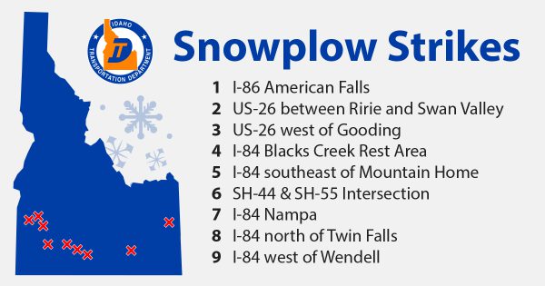
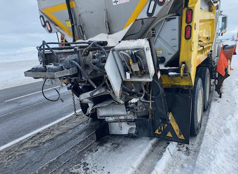
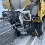
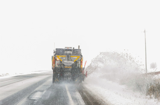
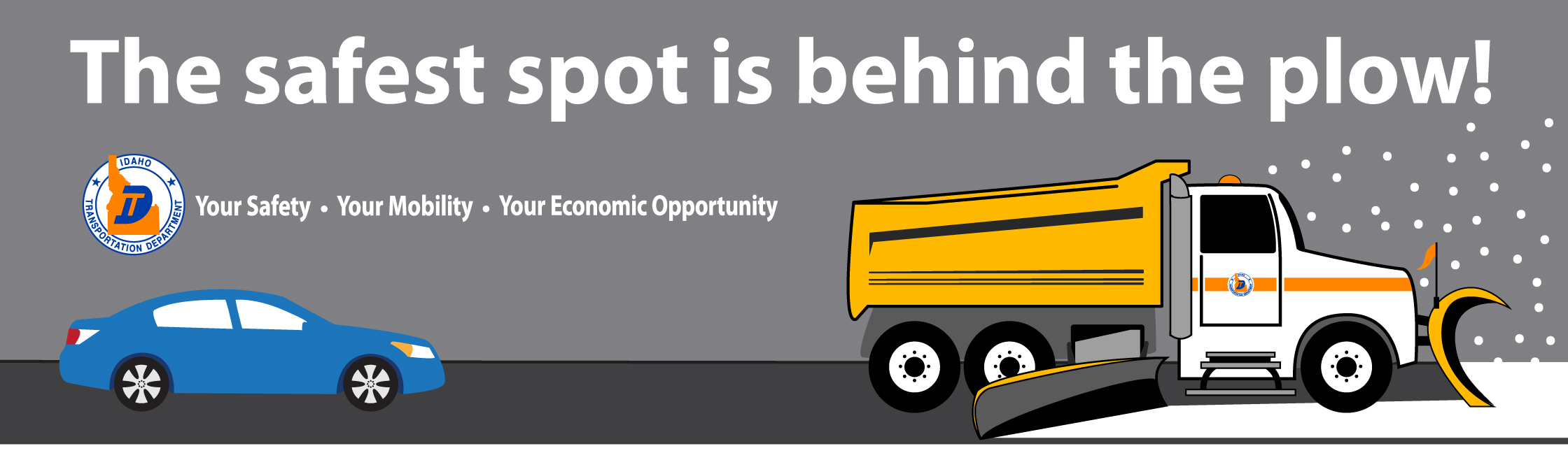
Winter weather has brought snowy driving conditions to much of Idaho. Unfortunately, the rise in snowy road conditions has also led to a sharp rise in snowplow strikes. Nine Idaho Transportation Department (ITD) plows have been hit so far this winter season. Five strikes happened over the last seven days.
Two of the most recent strikes happened this Wednesday in the Magic Valley, one on I-84 north of Twin Falls, and one on I-84 west of Wendell. Both involved a semi truck rear-ending a plow. The vehicles will be out of service for up to two weeks while they undergo repairs.
“It’s a major impact on maintenance sheds when equipment is taken out of service. We are limited on snowplows,” Jerome Foreman Brian Davidson said. “It makes it more difficult to keep roads clear.”
Another recent strike happened on Tuesday in Nampa. The plow was heading eastbound on I-84 near Karcher Road. A pickup pulling a trailer merged onto the interstate and lost control. The trailer swung out and hit the ITD vehicle’s wing plow. There was no lasting damage to the snowplow.
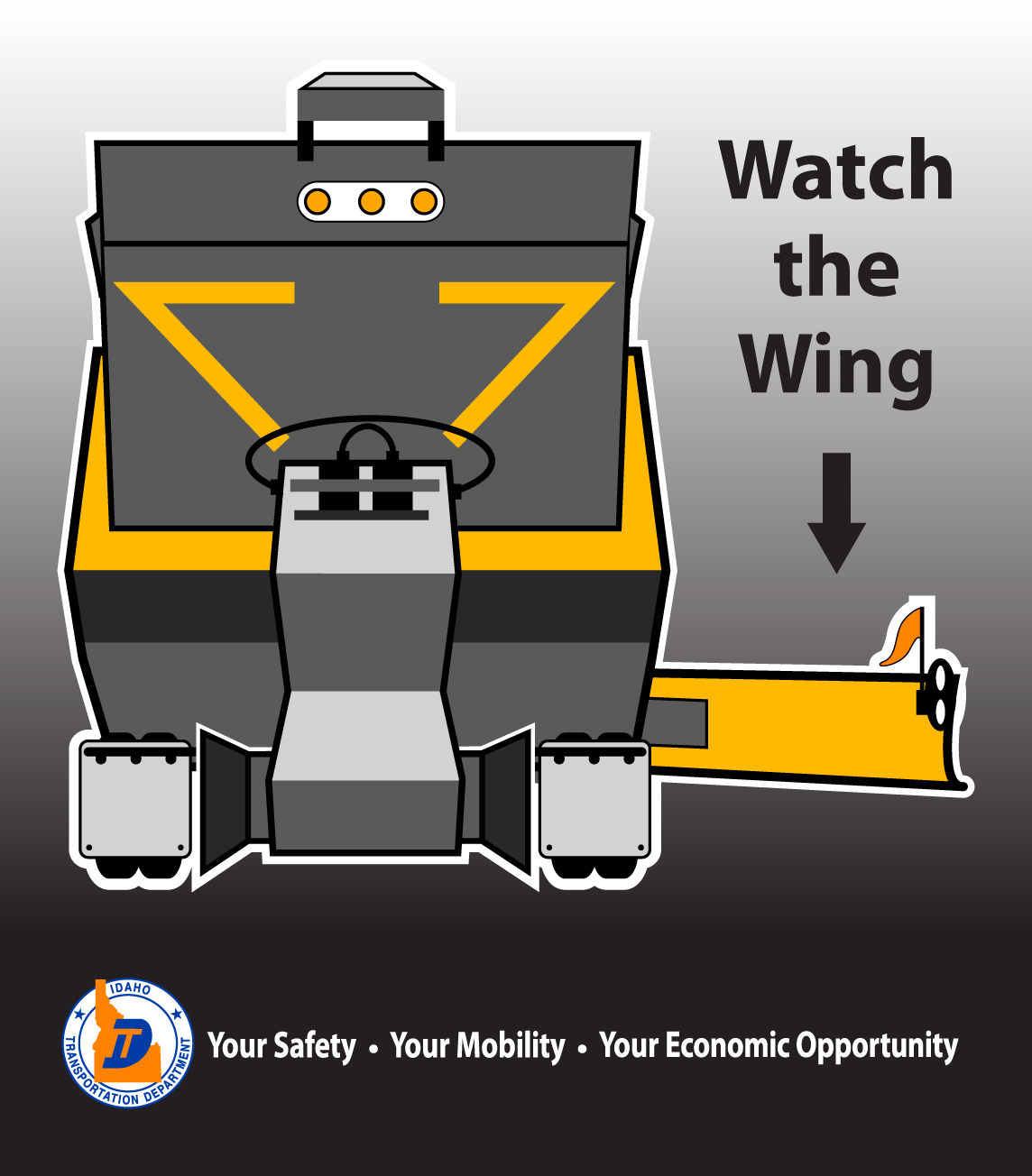
ITD wants to remind drivers how to be safe around snowplows.
- Do not pass a plow on the right. Plows have a 10-foot extendable wing plow on the right side that may be difficult to see in snowy conditions.
- Provide ample space for plows to work and steer clear of their blind spots. This also means increasing your following distance behind the plow.
- Practice patience and stay behind the plow for the safest road conditions.
- Plows often operate in pairs to clear multiple lanes; never position yourself between tandem plows.
- In case of a crash or if you need to stop on the side of the road, stay inside your vehicle for both your safety and that of our plow operators.
Last winter, there were 17 plow strikes, a number ITD does not want to repeat. Please be careful driving and mindful of our plows. Check 511.idaho.gov or the Idaho 511 App for road conditions before traveling. For more winter driving tips, visit itd.idaho.gov/travel.
*For real-time updates and photos of plow strikes, visit ITD’s Facebook or X pages.
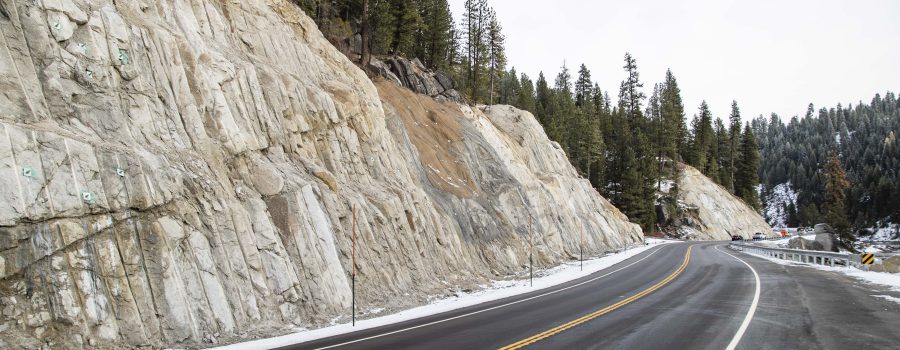
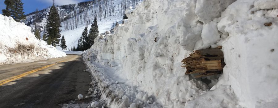
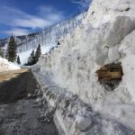
The Idaho Transportation Department will close State Highway 21 from Grandjean to Banner Summit this afternoon due to high avalanche risk.
A weather system bringing rain and snow is likely to trigger avalanches in this section of highway. The anticipated closure will begin at 4 p.m. today. However, actual weather impacts may require an earlier closure.
Motorists needing to use the roadway are advised to make the trip immediately or plan to use alternate routes. The alternate route between the Treasure Valley and Stanley area is to travel east on Interstate 84, exit in Mountain Home at Exit 95 to U.S. Highway 20 and then head north on State Highway 75.
The ITD avalanche crew monitors the snowpack along this section of highway in order to forecast the risk of avalanches large enough to reach the roadway. This practice allows the department to keep the highway open during the winter months with a reasonable confidence of safety for the traveling public.
There are around 70 avalanche paths in this 11-mile stretch of SH-21. Avalanches can be triggered without warning. For this reason, there is no parking or stopping within this section of road during the winter.
The highway will reopen when the snowpack has stabilized and the risk of active avalanches is reduced. Updates on closures and openings will be posted on 511.idaho.gov.
Blizzard conditions across much of the state has caused the Idaho Transportation Department to close several routes.
Current closures include:
Southwest Idaho:
- State Highway 21 from Grandjean Junction to Banner Summit
- State Highway 21 from Idaho City to Lowman
South-Central Idaho:
- U.S. Highway 93 from Jerome to Shoshone
- U.S. Highway 20 from Fairfield to Mountain Home
- U.S. Highway 30 from Hansen to Murtaugh
- State Highway 75 from Shoshone to Timmerman
- State Highway 46 from Gooding to Fairfield
Southeast Idaho:
- State Highway 34 from Conda to Wyoming
- State Highway 36 from SH-34 to Ovid
East Idaho:
- State Highway 47 from Ashton to Bear Gulch
- State Highway 32 from Tetonia to Ashton
- State Highway 33 from Newdale to Tetonia. Note that Teton Pass in Wyoming is also closed.
- U.S. Highway 26 from Ririe to Swan Valley
- State Highway 31 from Swan Valley to Victor
Plows will be out in full force today and until the winter weather subsides. The department asks that those who do not need to travel stay home or time their trips around weather conditions.
To share the road safely with plows, travelers are reminded to:
- Never pass a plow on the right.
- Give plows room to work by maintaining at least a three-second following distance.
- If multiple plows are working in tandem, do not attempt to move between them.
- Stay out of the blind spots.
- Drive for conditions.
- Allow extra time to travel.
More closures could be possible as the system moves through the state. Road conditions are updated 24/7 at 511.idaho.gov. Drivers are reminded to know before they go and visit the website or check the 511 app before traveling.


