System Adjustments cover the National Highway System, the Strategic Highway Network, Urban Boundaries, and Functional Classification for the state of Idaho. All systems are integral to each other and fall under the Federal-Aid Highways which create a means of eligibility for assistance. Information on the National Highways System, Urban Boundaries and Functional Classification can be found in the Code of Federal Regulations (CFR) Title 23 Part 470.
For questions regarding Functional Classification or Urban Boundaries please contact FunctionalClass@itd.idaho.gov.
Requesting a System Adjustment
ITD Board Policy 4061 states that:
“The Board Subcommittee on the State Highway System Adjustments is authorized to review and make recommendation of a State Highway System addition, removal or other State Highway System adjustment. The Board recognizes that local travel needs are most effectively met by the local highway jurisdiction using county highway systems and local roads.”
There are three categories in adjusting the State Highway System:
- Additions: Adding new segments to the State Highway System
- Deletions: Removing segments from the State Highway System
- Realignments: The designation of an existing State Highway System to a different segment of highway
For more information, please refer to Board Policy 4061 and Administrative Policy 5061 or contact FunctionalClass@itd.idaho.gov.
National Highway System (NHS)
What is it? Defined by the United States Code Title 23 Part 103, the National Highway System (NHS) is a system of public highways important to our nation’s economy, defense and mobility. Within the NHS, there are subsystems which include the Interstate System, Other Principal Arterials, STRAHNET, STRAHNET Connectors, and Intermodal Connectors.
Interstate: Created under President Dwight D. Eisenhower, the Interstate System retains a separate identity under the NHS.
Other Principal Arterials: Highways that exist in rural and urban areas that provide accessibility between an arterial and a major intermodal terminal such as Airports, Ports, Public Transportation Facilities, etc.
Strategic Highway Network (STRAHNET): A network of highways that are important for the United States strategic defense policy and provide defense access, continuity and emergency capabilities for defense purposes.
Major Strategic Highways Network Connectors: Provide access between major military installations and highways under STRAHNET.
Intermodal Connectors: Provide access between major intermodal facilities and the other subsystems under NHS.
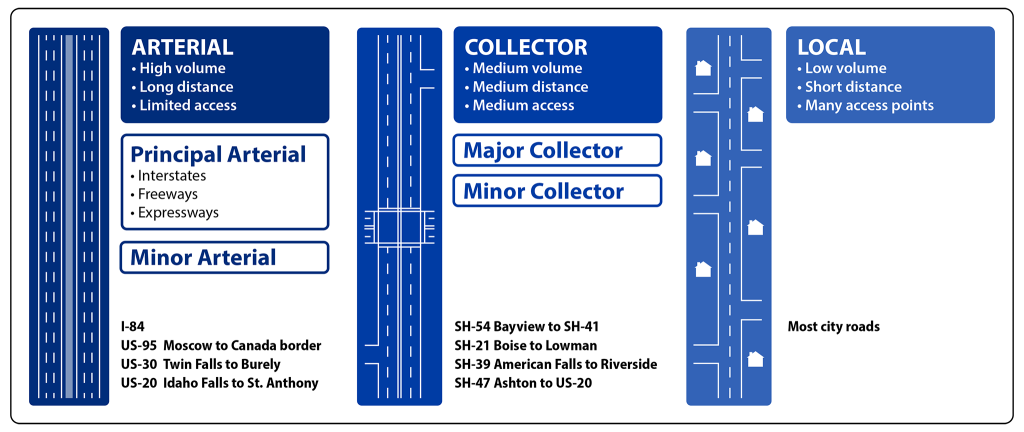
Functional Classification
What is it? Roads are classified by their service based on the community’s needs regarding accessibility and mobility. Each type of roadway has a primary purpose that defines its classification. High levels of mobility are generally called Arterials, and high levels of accessibility are called Locals. An equal balance of mobility and accessibility are called Collectors. While there are other factors to consider, accessibility versus mobility helps make distinction between the classes. Below are the subclassifications as such.
Arterials
Interstate: Also known as principal arterials, they are the highest classification and were created with long distances and mobility in mind. All interstates are “limited” or “controlled” access. Determining functional classification can be somewhat subject but interstates contain no ambiguity as they are officially designated by FHWA.
Other Freeways/Expressways: Roads must be divided highways with full or partial control of access. They primarily serve through traffic in federally defined urban areas.
Other Principal Arterials: Provide long distance but do not fit into the first two classifications. They primarily serve major metropolitan areas and provide a high level of mobility.
Minor Arterials: Provide service for moderate length trips and serve smaller geographic areas. They offer connectivity to the higher arterials and provide more land access. They link to cities and large towns that can attract travel over longer distances.
Collectors
Major Collectors: Serve both land access and traffic circulation in higher density locations. They channel trips between arterial and local roads, operate at higher speeds and connect rural areas to larger towns that are more directly being served by higher classifications.
Minor Collectors: Like major collectors, minor collectors serve both land access and traffic circulation but in a lower density area. They channel trips usually over less than ¾ of a mile and operate at lower speeds and fewer signalized intersections. Consistent with population, they collect traffic from local roads and all developed areas within a reasonable distance of a collector.
Locals
Local roads account for the largest number of miles for all roads. They are not made for mobility but rather accessibility and provide direct access to abutting land. Local roads discourage traffic.
To request a functional classification change, please see the documents below and email them to FunctionalClass@itd.idaho.gov.
Urban Boundaries
What is it? For transportation purposes, agencies have the option to use the national census to define urban boundaries exclusively or adjust boundaries to be consistent with their needs. Urban boundaries separate the urban and rural functional systems based on distinctive characteristics. An urban boundary is a significant factor when defining the functional classification of a road.
Urban: There are 2 types of urban areas
- Large Urban Areas: Population of 50,000 or more
- Small Urban Area: Population of 5,000-49,999
Rural: Population of 4,999 or less
To request an urban boundary adjustment, please see the documents below and email them to FunctionalClass@itd.idaho.gov.