Overview
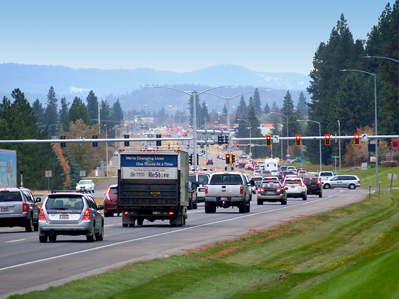
The Idaho Transportation Department and Kootenai Metropolitan Planning Organization are holding a fifth public meeting (in-person and online) in July 2026 for the Rathdrum Prairie Area Transportation Study. This study evaluates ways to improve safety, keep traffic moving efficiently and make the system more reliable as Kootenai County continues to grow.
The project team is evaluating four alternatives to identify the most effective transportation solutions and determine which alternatives move forward for further evaluation and project development.
July 2026 Online Meeting
Join us online for the fifth and final public meeting for the Rathdrum Area Transportation Study.
Process and Next Steps
ITD and KMPO started with 54 initial concepts during the Level 1 Screening. Based on public input and technical analysis, ITD and KMPO advanced 13 alternatives to Level 2 Screening and then recommended four Level 3 Alternatives.
The project team is screening Level 3 Alternatives and will prepare an Alternatives Evaluation Report with the publication of the study. At the July public meeting, ITD and KMPO will present the remaining alternatives and gather input to finalize the study. These remaining alternatives will move to the next step of the environmental review process, called the National Environmental Policy Act, or NEPA.
Recommendations and planning products, such as the traffic modeling, purpose and need and alternatives analysis, from the study and public and agency input may be adopted or incorporated into future National Environmental Policy Act (NEPA) studies, per 23 United States Code (USC) 168 or Federal Regulations (CFR) 450.212 and 450.318.
Funding
Currently, funding has been allocated to complete the transportation study and begin the NEPA review process, but any future recommended construction projects are unfunded. ITD and KMPO may explore funding options such as grants to advance these projects in the coming years. ITD and KMPO intend to work closely with local transportation agencies to support improvements that will address safety and enhance connectivity and mobility across the larger regional transportation network. Detailed information, including materials and resources presented at previous public meetings, is available below.
Community involvement
So far, ITD and KMPO have hosted four rounds of public meetings for the Rathdrum Prairie Area Transportation Study to inform the community and collect feedback on alternatives. The most recent public meetings were in September of 2025 in Post Falls and Coeur d’Alene. The in-person meetings drew 127 people and 314 people participated online. The public submitted 91 comment forms, which were used by the project team to shape future alternative analysis.
Now in the summer of 2026, join us for the fifth and final public meeting either in-person or online.
July 8, 2026
4:30–7 p.m.
Kootenai County Fairgrounds—Building 3
4056 North Government Way
Coeur d’Alene, Idaho 83815
If you are unable to join in person, participate online. The official comment period will run from July 8-22, 2026.
Public Meeting Summary Reports
-
Details public involvement activities for the Rathdrum Prairie Area Transportation Study after the initial round of public meetings in fall 2023.
-
Provides updates after the Level 1 analysis and recommendations for alternatives to be carried forward into Level 2 Screening.
-
Summarizes the in-person and online public meetings, which included 13 potential transportation improvement Level 2 Alternatives.
-
Describes the public engagement efforts for the Rathdrum Prairie Area Transportation Study leading up to the fourth round of public meetings in September 2025.
Timeline
Initially launched in 2022, the Rathdrum Prairie PEL Study is expected to be completed by the end of 2026.
-
2022
ITD and KMPO initiated the study.
-
Spring/Fall 2023
ITD and KMPO started public engagement efforts, including collecting input via a workshop, an initial community working group and a public meeting.
-
Summer 2024
ITD and KMPO screened 54 concepts and shared draft Level 1 transportation results at two public meetings.
-
Fall 2024
ITD and KMPO screened 54 Level 1 Concepts and eliminated or consolidated them into 13 Level 2 Alternatives that were presented to the public with a preliminary analysis of benefits and impacts.
-
Fall 2025
ITD and KMPO hosted public meetings to review Level 2 Alternatives and recommendations on alternatives to move to Level 3 Screening.
-
Summer 2026
ITD and KMPO will host a public meeting to present the remaining four alternatives and combinations of alternatives (called scenarios) and finalize the study.
-
Fall 2026
After reviewing feedback from the 5th round of public involvement, the study will be finalized and advanced to the NEPA process.
Frequently Asked Questions
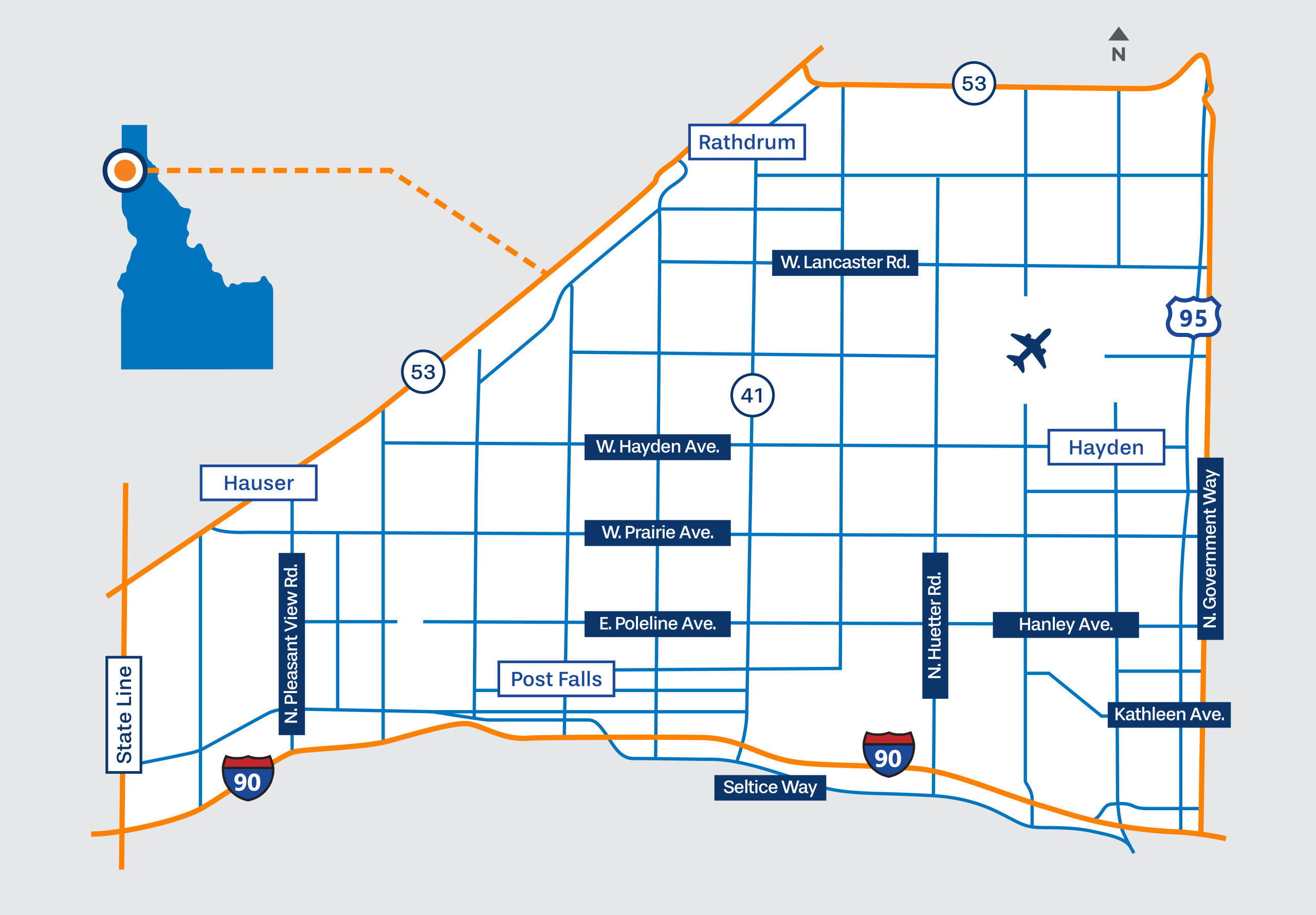
The Rathdrum Prairie Area Transportation Study is a planning project focused on identifying ways to improve travel in northern Kootenai County. The goals include improving safety, reducing congestion, enhancing connectivity and increasing reliability.
This study evaluates opportunities to improve travel in and around northern Kootenai County. It identifies where roads can be safer, where traffic is getting worse and what upgrades are needed as the county continues to grow. The study also reviews possible new road connections to give drivers more travel options and reduce congestion. By sharing your feedback, you can help ITD and KMPO choose solutions that support safety, growth and everyday travel for the whole community.
Level 3 Scenarios are two or three alternatives combined to form a long-term transportation solution. The scenarios are evaluated to identify the benefits and impacts. The alternatives included in the scenarios likely require NEPA review. Public input also plays an important role in choosing which alternatives advance.
ITD and KMPO reviewed each Level 3 Alternative to see if the relative benefits and impacts were better when combined with other alternatives. If combined, the alternative was refined and included in the Level 3 Scenario screening. From there, the most promising scenarios will be selected for detailed analysis as part of a strategy for next steps, including NEPA.
Since 2022, ITD and KMPO have gathered input from community members, stakeholders and agencies through interviews, a workshop and public meetings. The feedback helped shape the current screening criteria, alternative refinement and recommendations. Some examples of public input include utilizing existing corridors, considering east-west travel patterns, minimizing property impacts, and incorporating opportunities for transit, bicycle and pedestrian users.
Yes, a combination of alternatives or scenarios is being explored in the Level 3 Analysis to address multiple transportation challenges. This approach helps create more flexible and effective solutions that meet regional travel needs. For example, a north-south highway option could be paired with an east-west highway option to improve connectivity.
Funding strategies, including developer contributions, may be considered during specific project planning or design phases. These strategies can help with project costs and support long-term growth improvements. Final decisions on funding will be made in coordination with relevant agencies and stakeholders.
Under the expanded highway alternatives, the existing signals would remain. However, some intersections could be redesigned or upgraded during later engineering phases to improve traffic flow and safety.
The study looks ahead to 2045, matching KMPO’s traffic projection models that include growth and land use plans from the cities and county. With this projected growth and increase in vehicles on the roads, the alternatives are designed to meet traffic demand forecasts for 2045, with many supporting the demand and having extra capacity.
ITD and KMPO will continue evaluating Level 3 Alternatives using the following steps:
Contact the project team
For questions or comments about this project, please contact the project team at info@rathdrumprairiepel.com or (208) 772-1200.
Join the project email list!
Stay up to date on the Rathdrum Prairie Area Transportation Study as we work to identify transportation issues and potential solutions across the Rathdrum Prairie.
Traffic and Study Memos
-
This memo documents revisions to the Rathdrum Prairie Level 2 alternatives screening analysis, confirms that identified discrepancies did not affect the results, and summarizes the public review process and final recommendations.
-
Rathdrum Prairie Area Transportation study concepts and alternatives evaluation process methodology memo