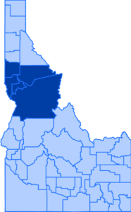
ITD and ISP to host winter driving class in Lewiston on December 13

Picture of a ISP trooper and a ITD operator presenting to a classroom and sharing winter driving tips.

The Idaho Transportation Department and Idaho State Police are teaming up to provide a free, informative and engaging winter driving safety class on Saturday, December 13 in Lewiston as the region prepares for icy roads and adverse weather.

The classes are designed to help drivers prepare for Idaho’s winter conditions by covering topics like vehicle readiness, proper equipment, defensive driving techniques, and how to safely share the road with snowplows. Instructors include state troopers and ITD operators who bring firsthand experience from years of working on Idaho’s roads and responding to emergencies during severe weather.

While these classes are open to everyone of all ages and skill levels, they are especially valuable for:

  • Young drivers with limited winter driving experience
  • New drivers, including those preparing to start driver’s education in the next year
  • New residents facing their first Idaho winter

Lewiston Winter Driving Class event details:

  • Saturday, December 13
  • 10 a.m. – 12 p.m.
  • ITD District 2 Office, 2600 Frontage Road, Lewiston, ID 83501 (The main entrance is on the south side of the building near the flag poles.)
  • Register online here. Seating is limited. Additional courses may be scheduled later.

More information can be found on ITD’s website Travel page, itd.idaho.gov/travel.

US-12 emergency rock scaling project to reduce likelihood of rockfall

Picture taken from a drone on a cloudy day above US-12 and overlooking the rocky slope by Arrow Bridge.

WEDNESDAY, NOVEMBER 26 UPDATE:

U.S. Highway 12 near Arrow Bridge reopened all lanes of traffic as of 2:30 p.m. today. Crews completed rock scaling, excavation and cleanup work on the rocky hillside after a section of the slope shifted, causing loose rocks to create a safety hazard. Traffic may now travel on US-12 near Arrow Bridge without interruption.

As an additional safety measure, a concrete barrier has been placed near the edge of the roadway to protect motorists should any small rocks or debris come loose. Crews worked around the clock and removed an estimated 350 truckloads of debris from the hillside since Friday.

“A big thank you to both our construction partners and maintenance crews for mobilizing and tackling the slope so quickly,” Operations and Traffic Engineering Manager Jared Hopkins said. “I would also like to extend ITD’s appreciation to other partners including the Idaho State Police, Idaho Fish and Game, Nez Perce County Sheriff, Nez Perce County Road and Bridge, and the City of Lewiston Fire Department for their help orchestrating this multiday, emergency project on US-12.”

On the US-12 emergency slope project near Arrow, a loader empties a bucket of rocky debris over a truck bed.

With holiday travel approaching, drivers are reminded to use Idaho 511 for the most up-to-date traffic and road condition information across the state. Travelers can visit the website at 511.idaho.gov, dial 5-1-1 or download the Idaho 511 app on any smart device.

TUESDAY, NOVEMBER 25 UPDATE:

U.S. Highway 12 near Arrow Bridge will re-open one lane at 4 p.m. this afternoon for commuters. The crack has been stabilized and loose rock over a large section of the slope has been removed.

Drivers should use caution when approaching the work zone and be ready to stop when instructed. Flaggers will allow alternating lanes of traffic to travel through with delays lasting up to 20 minutes. Overnight, operators will continue their systematic work of loading and hauling away debris.

Loaders can be seen working in tandem near the base of the slope on US-12 near Arrow bridge.

ITD will continue to provide any necessary updates during the cleanup process. The most recent schedule can be found at https://itd.idaho.gov/news/us-12-emergency-rock-scaling-project-starts-today-to-reduce-likelihood-of-rockfall/.

Additionally, drivers should continue to use Idaho 511 for the most up-to-date traffic and closure information. Travelers can visit the website at 511.idaho.gov, dial 5-1-1 or download the Idaho 511 app on any smart device.

MONDAY, NOVEMBER 24 UPDATE: 

The Idaho Transportation Department is scheduled to close U.S. Highway 12 near Arrow Bridge tomorrow from 9 a.m. to 5 p.m. to allow crews to continue addressing the emergency rock scaling project that started last week. Motorists will be redirected to alternative routes on U.S. Highway 95, State Highway 3, State Highway 13, and State Highway 162.

The highway reopened to one lane over the weekend after work progressed well, but additional heavy equipment modified with special attachments should arrive in the morning to address the remainder of the slope. This closure is necessary to keep the public safe.

Workers can be seen on the slope above US-12 and equipment excavates in the distance.

ITD will provide any necessary updates as the work progresses throughout the day. However, motorists should plan for a closure extending to 5 p.m. The most recent schedule can be found at https://itd.idaho.gov/news/us-12-emergency-rock-scaling-project-starts-today-to-reduce-likelihood-of-rockfall/.

Additionally, drivers should continue to follow Idaho 511 for the most up-to-date traffic and closure information. Travelers can visit the website at 511.idaho.gov, dial 5-1-1 or download the Idaho 511 app on any smart device.


SATURDAY, NOVEMBER 22 UPDATE:

U.S. Highway 12 near Arrow Bridge has re-opened one lane this evening with flaggers allowing a single, alternating lane of traffic to pass through the work zone through the night. Drivers should plan for delays of up to 20 minutes.

Workers attached to ropes carefully transverse a rocky slope high above US-12 by Arrow bridge.

This is a dynamic project, with conditions that may change quickly so ITD encourages the public to use Idaho 511 for the most up-to-date traffic and closure information. Travelers can visit the website at 511.idaho.gov, dial 5-1-1 or download the Idaho 511 app on any smart device.


FRIDAY, NOVEMBER 21 UPDATE:

All lanes of U.S. Highway 12 near Arrow Bridge will temporarily re-open to traffic starting at 5:30 p.m. tonight until 8:00 a.m. tomorrow morning. Crews have made significant progress on the slope above US-12 and engineers have deemed it safe to open for traffic through the night.

Drivers should expect flaggers throughout the area to monitor traffic and the slope for safety.

Work will start again tomorrow morning, closing US-12 at 8:00 a.m. If all goes as planned, ITD aims to reopen the highway at 5:00 p.m. tomorrow evening. Idaho 511 is the best resource for drivers with updated traffic conditions, detour routes and closure information.

High up on the slope above US-12 near Arrow Bridge, a rock scaling worker pulls on a line.

Please use caution through the area and be aware of the possibility of debris in the roadway as work continues to clear the slope of loose rocks through the weekend.

Up-to-date traffic information and the latest schedule for this project can be found by visiting 511.idaho.gov. Travelers can also dial 5-1-1 or download the Idaho 511 app on any smart device.


THURSDAY, NOVEMBER 20 UPDATE:

All lanes on U.S. Highway 12 near Arrow Bridge will close tomorrow at noon for rock scaling. Crews will proactively dislodge large rocky sections from the nearby slope under controlled conditions which decreases the likelihood of future rockfalls that create a safety hazard for drivers. Traffic will be detoured to alternative state routes on U.S. Highway 95, State Highway 3, State Highway 13, and State Highway 162.

The closure will stay in place around the clock until crews finish removing unstable rock. Because conditions on the slope can vary, a specific reopening time can’t be set in advance. Drivers should plan for an extended closure. However, if work progresses smoothly, the closure is not expected to last more than a day or two. At this time, we do not expect this closure to impact the Thanksgiving holiday.

“The decision to close the highway was made from a safety standpoint to protect travelers from falling rocks and to allow for a timelier cleanup process,” Operations and Traffic Engineering Manager Jared Hopkins said. “Heavy equipment will load trucks with the freshly fallen rocks and those will be hauled offsite.”

A view of two workers installing anchors near the top of the slope for the US-12 emergency rock scaling project by Arrow bridge.

In addition, there will be increased truck activity outside of the work zone. Trucks will frequently be entering and exiting the highway on US-12 by Cherry Lane Bridge and near the south end of Arrow Bridge.

Experts have been monitoring the slope since Tuesday to ensure there is no danger to drivers and flaggers have been providing traffic control. Motorists should also pay close attention to road signs posted in the area.

Up-to-date traffic information can be found by visiting 511.idaho.gov. Travelers can also dial 511 or download the Idaho 511 app.


WEDNESDAY, NOVEMBER 19 UPDATE:

Rock scaling crews arrived on site today in preparation for the US-12 emergency roadside project near Arrow Bridge. The slope was evaluated and will be prepped for scaling.

Anchor points will be installed so that workers can climb the slope with their equipment. It is anticipated that the rock removal will begin on Friday.

While rocks are dislodged, flaggers will stop traffic at a safe distance. Delays will be 20 minutes at a time. If conditions change, a full closure may be implemented for safety.

A drone photo of the slope near US-12 and Arrow Bridge prior to the emergency rock scaling project.

Up-to-date traffic information can be found by visiting 511.idaho.gov. Travelers can also dial 5-1-1 or download the Idaho 511 app.


TUESDAY, NOVEMBER 18 UPDATE:

The Idaho Transportation Department is conducting rock scaling work to stabilize the slope above U.S. Highway 12 near Arrow Bridge between mileposts 15 and 16. This effort began today and is expected to continue through the middle of next week. Work will intermittently affect traffic.

Scaling involves wedging and prying debris loose proactively, with rocks falling from the hillside down to the road. Specialized equipment will excavate rock at the top and flatten the slope.

“We are taking a proactive approach by dislodging any unstable material with professional scalers in a controlled setting,” Operations and Traffic Engineering Manager Jared Hopkins said. “For the safety of the traveling public, we’ll have flaggers there to monitor the slope and stop traffic while workers are scaling.”

An anticipated work schedule is as follows and is subject to change based on conditions:

  • Tue., Nov. 18 – Thu., Nov 20: Flagging operations with 20-minute delays.
  • Fri., Nov. 21 – Sun., Nov. 23: Full closure potentially all day and overnight. Motorists will be detoured to alternative route on State Highway 13 or State Highway 162.
  • Mon., Nov. 24 – Wed., Nov. 26: Flagging operations with 20-minute delays until work concludes.

“If the slope becomes too unstable, an extended closure may be needed and drivers will be detoured to State Highway 13 or State Highway 162 in that case,” Hopkins said. “As work continues, we may allow traffic to flow without being stopped during work if it is safe to do so.”

Up-to-date traffic information can be found by visiting 511.idaho.gov. Travelers can also dial 5-1-1 or download the Idaho 511 app.

Input sought on long-range planning for transportation in Idaho

People review a map of a proposed project

The Idaho Transportation Department is seeking input on long-range planning for transportation across the state through a series of public meetings in the next month.  

Comments will inform the update to ITD’s Statewide Long-Range Transportation Plan, a federally required strategy document that is updated every five years and is used by the Idaho Transportation Board and planning staff as a guide to program future studies and projects.  

Open houses will be held in each region of the state:   

  • Nov. 18 in Pocatello at the Portneuf Medical Center (777 Hospital Way) 
  • Nov. 19 in Idaho Falls at the Crosspoint Community Church (1900 Grandview Drive) 
  • Dec. 2 in Coeur d’Alene at the Hampton Inn and Suites (1500 West Riverstone Drive) 
  • Dec. 3 in Lewiston at the Lewiston Community Center (1424 Main Street)  
  • Dec. 4 in Boise at Mountain View High School Library (2000 South Millennium Way) 
  • Dec. 8 in Twin Falls at the College of Southern Idaho (315 Falls Avenue)  

All events will take place 3 – 7 p.m. The same material will be shared online, with comments sought from Nov. 18 to Jan. 10. 

ITD’s Long-Range Transportation Plan will look at the needs of the transportation network out to 2050 and consider a variety of factors including growth, travel demands, land use, safety, economic development, system reliability and anticipated revenue.  

“This policy document looks at current conditions, existing plans and future trends in Idaho and lays the foundation for ITD to continue to deliver on our mission of safety, mobility and economic opportunity,” said Amy Schroeder, the division administrator for planning. “It’s not necessarily about identifying specific projects. It’s about determining, through data analysis and public input, the best strategy for investing in the transportation system given the variability of future revenue.”  

The plan comes at a time of extraordinary growth and funding uncertainty. Besides seeking public feedback, ITD is engaging with other planning organizations as the plan will look at the transportation network as a whole, which extends beyond state-managed highways to locally owned routes and alternative modes of transportation.  

“This is about working with local jurisdictions and planning agencies to address congestion in major cities,” Schroeder said. “It’s also about adopting a statewide perspective and recognizing that it’s just as important to look at improving safety and reducing fatalities in our rural areas.”  

An additional public comment period to review the draft plan is planned for summer 2026, and the plan is expected to be released in 2027.  

ITD seeks public feedback to help shape the future of rail in Idaho

Railroad tracks in Nampa

UPDATE: Some users are reporting issues submitting their responses and being unable to proceed past the second page. We recommend that respondents hit the next button at the bottom more than once. If that doesn’t work, we encourage users to sign up to receive a different format of the survey, which will be available the week of Nov. 3. We are working to resolve any technical issues in the meantime.

The Idaho Transportation Department is updating the Idaho Statewide Rail Plan and is asking for public input to help guide the future of rail infrastructure across the state. 

The plan evaluates the current condition and performance of Idaho’s rail network, identifies system-wide challenges and opportunities, and outlines strategies to strengthen rail infrastructure. The plan will also explore key topics such as rail safety, grade crossings, and access for rail-served industries that help drive Idaho’s economy. 

Unlike other statewide transportation plans, this plan does not allocate funding for specific projects. Instead, it provides a strategic foundation that supports future grant applications and coordination with the Federal Railroad Administration and other partners. 

“We want to hear from Idaho communities about how rail infrastructure is working today and what improvements would make the biggest difference in the future,” Freight Program Manager Caleb Forrey said. “Your feedback will help us better understand statewide priorities and shape a plan that reflects Idaho’s needs.” 

Railways in Idaho are operated by the private sector, with ITD having shared responsibility for safety at highway-rail crossings. As is the case with public transportation in Idaho, there are no dedicated state funding sources for freight or passenger rail beyond match funds for federally-funded improvements to rail crossings.

The online survey is open through November 12 and takes about five minutes to complete. Feedback collected will be summarized in the final plan, which is expected to be released in spring 2026, and used to guide discussions with communities, railroads, and state and federal partners. 

A summary of the rail plan is available at itd.idaho.gov/planning. 

US-95 work starts up again near Riggins on Monday

Picture of a rocky slope by US-95 near Riggins.

Starting Monday crews will resume work on rocky slopes near Riggins on U.S. Highway 95.

South of Riggins at milepost 189 in the vicinity of the Sheep Creek Rest Area, scalers will install reflective prisms on the rock face above the roadway to monitor slope movement and will remove loose rocks for safety.

Intermittent delays of up to 20 minutes between the hours of 8 a.m. and 6 p.m. are likely for the next week. Flaggers will hold traffic in both directions to keep everyone safe with rocks coming off the slope. Crews will periodically allow one lane of traffic through the work zone.

North of Riggins at milepost 196.5, in the vicinity of “Bull’s Eye Corner,” crews will also close the shoulder and replace damaged signs as part of safety efforts that started last fall.

Rocks may be present in the roadway and motorists should always exercise caution when traveling though this river corridor.

Live traffic impacts across the region can be found by visiting 511.idaho.gov. Travelers can also dial 5-1-1 or download the app.

Four-lane section of US-95 south of Moscow fully open

View of the new pavement near the southern section on the US-95 Thorn Creek to Moscow route.

Starting Sunday drivers will be able to take all six miles of the new four-lane section of U.S. Highway 95 from Reisenauer Hill to Moscow.

Drivers had only been able to travel the first five miles that opened in early July as crews needed to finish work at the Thorn Creek Bridge. With the bridge now complete, drivers can experience the route with minimal delays. Some construction will continue over the next several weeks as crews finish installing permanent barrier, signs, delineators and rumble strips.

Construction of this nearly $90 million realignment began in 2022 to shift the curving, two-lane highway to the east and expand it to four lanes. The new route was funded partially by Governor Little’s Leading Idaho program and was designed to be safer with a flatter grade, fewer curves and better access control.

“We are honored and pleased to provide this much-needed expansion to the region,” District Engineer Doral Hoff said. “Completing this last portion between Lewiston and Moscow gives drivers a safer and more efficient route.”

The project first began in 1999 when the Idaho Transportation Department started efforts to expand all of US-95 to four lanes from the top of Lewiston Hill to Moscow. This six-mile segment was the last to be improved, with most of the corridor undergoing construction in the early 2000s.

Expect one-lane closures for geotechnical work next week

Roadside view near the bottom of Bear Ridge Grade on SH-3.

Travelers on U.S. Highway 95 and State Highway 3 should plan for flagging operations to be in effect next week as the Idaho Transportation Department conducts valuable geotechnical investigations on these routes. Operations will involve boring into the roadway to allow ITD to plan for resurfacing projects scheduled to be completed next year.  

Work on SH-3 will begin on Monday and run from milepost 13 to 18 at the bottom of Bear Ridge Grade. Traffic will be reduced to one lane, with flaggers indicating movement for each direction. Delays are expected to be less than 15 minutes. This work zone will be active for just two days, with exploratory drilling anticipated to be completed on Wednesday.  

Escape ramps and turnouts in this vicinity of SH-3 will be closed while work is underway. A traffic control crew will notify truckers at the brake check area on the top of the grade. 

One lane will also be closed on US-95 beginning next Wednesday from milepost 241 to 251 near Grangeville in the Johnston Road area. These efforts are expected to be completed by Friday.  

The work schedule is subject to weather conditions and may change. Updates and information on these work zones and others across Idaho can always be found on the Idaho 511 app or by visiting 511.idaho.gov. 

Delays for US-95 travelers between Moscow and Lewiston this week

Bridge work using heavy equipment on Thorn Creek Bridge over US-95 near Lewiston, Idaho.

Beginning this Wednesday, motorists using U.S. Highway 95 from Lewiston to Moscow will see greater delays at the Thorn Creek work zone as crews pour concrete.

A speed reduction will be in place over the Thorn Creek Bridge that will cause delays of approximately 20 minutes. Delays could be longer during commuting hours. Traffic will be slowed to a strict 5 mph over the structure to ensure vibrations do not impact the curing process for the high-strength concrete. Concrete work is expected to be done on Wednesday, with curing necessary on Thursday and Friday. Restrictions will be in effect, though there may not be active work on site.

Drivers are encouraged to plan ahead and avoid delays by taking State Highway 8 and then the Moscow-Pullman Highway in Washington as an alternate route.

Work at the Thorn Creek Bridge is one of the few remaining steps in completing the new four-lane section from Reisenauer Hill to Moscow. Construction began in 2022 to shift the curving, two-lane highway to the east and expand it to four lanes. The nearly $90 million realignment was funded partially by Governor Little’s Leading Idaho program and was designed to be safer with a flatter grade, fewer curves and better access control.

Five miles of the new alignment opened to traffic in early July. This last mile is expected to be complete by November.

Traffic updates on this project and others across Idaho can always be seen on the Idaho 511 app and at 511.idaho.gov.

US-95 Aht’Wy Plaza receives safety features and repairs

Picture of the US-95 Aht’Wy interchange looking across with traffic moving on either side.

Crews are out on U.S. Highway 95 near the Aht’Wy Plaza installing safety features and signage to help guide travelers through the interchange. They will also remove and repave nearly 100 feet of pavement to fix a soft spot near the east side of the interchange.

Caution is advised when approaching the work zone as flaggers may be present on either side of the highway. Motorists can expect at least one travel lane to be closed in each direction and may experience delays of up to 30 minutes. Crews will be working weekdays from 6 a.m. to 6 p.m. All work is estimated to take two weeks to complete.

To improve safety yellow tubular delineators will be permanently adhered to the centerline to separate opposing traffic and deter southbound motorists from making dangerous left turns across the highway.

Also, green directional signage will be posted at critical locations and new pavement markings will be painted to enhance navigation around the plaza. Southbound travelers wanting to access the gas station or casino must use the exit at Nez Perce Drive. Only northbound travelers may use the right-hand turn lane to exit into the gas station. Both directions of travel on the highway may continue to use the interchange to access the plaza.

Up-to-date traffic information may be found by visiting 511.idaho.gov. Travelers can also dial 5-1-1 or download the app.

Repaving starts Monday on SH-14 near Elk City

Picture of the roadway on SH-14.

Work on State Highway 14 near Elk City will begin Monday to repair potholes and resurface 10 miles of the highway. Shoulders in poor condition will also be repaved to further enhance safety.

When approaching the work zone, motorists can expect flaggers and delays between 15 to 30 minutes. The highway will be reduced to one lane of alternating traffic guided by pilot cars. Crews will start at milepost 23 and work east towards milepost 33 and Elk City.

All work will temporarily shut down by 6 p.m. on August 7 in preparation for Elk City Days held August 8-10. Highway crews will start back up again on August 11.

Paving will significantly improve rideability and make it a safer road for the traveling public.

This $2.5 million project is anticipated to wrap up mid-September.

Up-to-date traffic information may be found by visiting 511.idaho.gov. Travelers can also dial 5-1-1 or download the app.