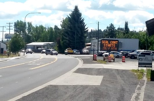
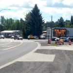
To extend the life of previously completed highway projects, sealcoats will be applied to several highways throughout the region starting July 9. The newly-treated surface helps preserve the pavement and provides for better vehicle traction.
When sealcoats are applied, roadways will be reduced to one lane. Motorists should anticipate short delays and watch for the presence of pilot cars.
Sealcoating is a roadway surface treatment best applied during the hot and dry months of summer when chips of aggregate will properly adhere to an oil layer deposited on the highway.
Drivers are cautioned to slow down and pay attention within the work zones, as chips placed during the sealcoating process have the potential to cause windshield damage.
Crews will begin applying sealcoats in the order below:
July 9: Idaho Highway 8 from Moscow to Troy (11.7 miles)
July 12: Idaho Highway 8 from Deary to Bovill (10.2 miles)
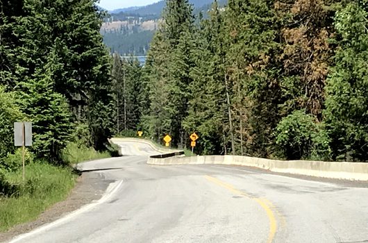
July 16: Idaho Highway 11 from Greer to the top of Greer Grade (8 miles)
July 20: Idaho Highway 11 from Weippe to Grangemont Road (11 miles)
All sealcoats are expected to be completed by the end of July.
Repairs to Idaho Highway 5 near Plummer will begin the week of July 9.
Construction will fix damage caused by a March 2017 landslide at milepost 5.8. Crews will remove and replace unstable material below the highway. New material is designed to anchor the hillside and prevent future landslides.
Travelers can expect short delays while flaggers and signals guide traffic through the one-lane work zone. Crews will typically be on site every day but Sunday.
Construction will last two months. Check 511 for the latest traffic updates.
Fifty miles of US-12 will be paved this summer to improve mobility and safety in the area, with work set to start on the first section during the week of July 9.
The 27-mile section between Tumble Creek and Saddle Camp Road will be resurfaced first, followed by the 23-mile section between Warm Springs and the Idaho-Montana border, which is expected to begin in August.
The highway will be reduced to one lane during both paving projects, with flaggers and pilot cars in place to guide traffic through work zones. A daytime shuttle service will be provided to safely transport bicyclists through the longer work zones. Once a schedule is finalized, it will be published on the project website and the corridor newsletter.
Paving operations are anticipated to take place at night to minimize impacts to the traveling public, but travelers should expect flagging operations and delays during the day.
During construction, travelers on US-12 between Lowell and the border should plan for delays up to two hours, as other projects to replace Fish Creek and Maggie Creek bridges are already underway. Due to the remote location and length of the work zones, travelers are also advised to fill up their gas tanks before driving through construction.
Construction for all US-12 projects will conclude this summer, bringing nearly $17 million of much-needed infrastructure and safety improvements.
To learn more and to subscribe to updates, visit itd.idaho.gov/US12. For immediate construction impacts on this and other routes, visit 511.idaho.gov.
To extend the life of previously completed highway projects, sealcoats will be applied to several highways throughout the region starting the week of July 9.
When sealcoats are applied, roadways will be reduced to one lane. Motorists should anticipate short delays and watch for the presence of pilot cars.
Sealcoating is a roadway surface treatment best applied during the hot and dry months of summer when chips of aggregate will properly adhere to an oil layer deposited on the highway. The newly-treated surface helps preserve the pavement and provides for better vehicle traction.
Drivers are cautioned to slow down and pay attention within the work zones, as chips placed during the sealcoating process have the potential to cause windshield damage.
Sealcoating projects scheduled to occur this summer along with their anticipated start date, location and length are as follows:
July 9: Idaho Highway 3 — approximately 31 miles from the Coeur d’Alene River Bridge to the Canyon Creek Road area
July 16: Idaho Highway 58 — approximately 3 miles from the Washington border to the US-95 junction
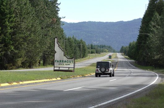
July 17: Idaho Highway 54 — approximately 3.5 miles from the Goodhope Road traffic circle through Farragut State Park
July 18: US-95 — approximately 6 miles from Fawn Lane to the Idaho Highway 1 junction
July 19: US-95 — approximately 19 miles from Samuels Road to Tamarack Street
Crews will repaint the highways after sealcoating. All work is expected to be completed by early August.
The Idaho Transportation Department is seeking public comment from July 1 – July 30 on the FY 2019-25 draft of the Idaho Transportation Investment Program (ITIP), and all transportation stakeholders are encouraged to participate.
The ITIP is a seven-year “roadmap” for planning and developing transportation projects, including:
– Highways and bridges
– Bicycle and pedestrian facilities
– Highway safety
– Railroad crossing safety
– Airports
– Public transportation
– Transportation planning
– Freight
The transportation department is offering an online, interactive map that allows users to choose specific project categories, and learn about work that is planned for the area of Idaho they’re interested in. It’s called the Idaho Transportation Project Map.
The draft ITIP document lists projects by highway route and location, identifies projected years for right-of-way acquisition, preliminary engineering, construction and estimated project costs. It also lists local construction projects that are federally funded.
The projects start in 2019, and go through 2025.
Public comments will help the department determine if proposed projects meet the department’s three main objectives of improving safety, mobility and economic opportunity.
Production of the ITIP is a year-round process that relies on input from elected officials, citizens, tribal governments, other state and federal agencies, Idaho’s metropolitan planning organizations, the Local Highway Technical Assistance Council, and other interested organizations.
Comments can be e-mailed to adam.rush@itd.idaho.gov or mailed to ITIP – Comments, Attn: Adam Rush, P.O. Box 7129, Boise, ID 83707-1129. Paper or CD copies of the ITIP will be provided upon request by contacting Rush at (208) 334-8119 or by e-mail at adam.rush@itd.idaho.gov.
A request for a paper copy or CD also can be mailed to: Idaho Transportation Department, Adam Rush, P.O. Box 7129, Boise, ID 83707-1129.
A printed copy can be reviewed at any of ITD’s district offices in Coeur d’Alene, Lewiston, Boise, Shoshone, Pocatello and Rigby.
All comments on the draft will be reviewed after July 30. After approval by the Idaho Transportation Board, the ITIP is submitted to the Federal Highway Administration, the Federal Transit Administration and the Environmental Protection Agency.
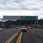
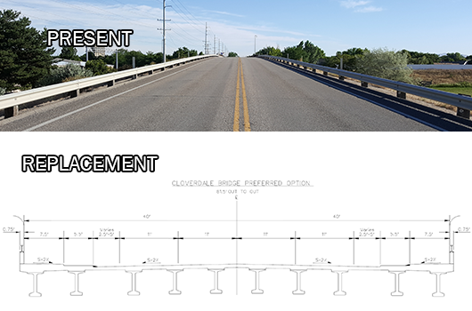
The Idaho Transportation Department will close the left-most lane of eastbound Interstate 84 beneath the Cloverdale Overpass Sunday,July 1. This will allow crews to perform work in preparation for replacing the damaged bridge.
Crews will drill beneath the existing bridge to test the soil composition. This will inform what treatment is needed for the foundation of the replacement bridge for Cloverdale Road. The replacement, currently being designed by ITD engineers will feature four 11-foot travel lanes, 5.5-foot raised bike lanes, and 7.5-foot sidewalks.
The single-lane closure is expected to begin early Sunday morning and stay in place for most of the day.
Drivers are encouraged to use caution in the work zone. For updated information on traffic impacts on the State Highway System, please visit 511 online at 511.idaho.gov.
UPDATE 7/3/18: Second water test comes back clean, so boil order lifted and water fountain reopens this afternoon. UPDATE 6/30/18: Additional water testing at the Hagerman rest area on US-30 has come back negative for E. coli. Another test is slated for today, Monday 7/2.
Below is the initial release on the subject:
SHOSHONE—On Thursday, June 28 E. coli bacteria were found in the Hagerman Rest Area water supply located south of Hagerman on US-30. The discovery was made during routine quarterly testing conducted by the Idaho Transportation Department.
Drinking fountains have been disabled but the rest area will remain open while ITD works with the Idaho Department of Environmental Quality to investigate the cause and take corrective actions on the issue.
Bacterial contamination can occur when increased run-off enters the drinking water source (for example, following heavy rains). It can also happen due to a break in the distribution system (pipes) or a failure in the water treatment process.
What should I do? What does this mean?
DO NOT DRINK THE WATER WITHOUT BOILING IT FIRST. Bring all water to a boil, let it boil for one minute and let it cool before using, or use bottled water. Boiled or bottled water should be used for drinking, making ice, brushing teeth, washing dishes, and food preparation until further notice. Boiling kills bacteria and other organisms in the water.
E. coli are bacteria whose presence indicates that the water may be contaminated with human or animal wastes. Human pathogens in these wastes can cause short-term effects, such as diarrhea, cramps, nausea, headaches, or other symptoms. They may pose a greater health risk for infants, young children, the elderly, and people with severely compromised immune systems.
The symptoms above are not caused only by organisms in drinking water. If you experience any of these symptoms and they persist, you may want to seek medical advice. People at increased risk should seek advice from their healthcare providers about drinking this water.
What is being done?
ITD is completing a comprehensive assessment of the water system as well as monitoring and operational practices to identify and correct any causes of the contamination.
Public will be informed when tests show no bacteria are present and there is no longer need to boil drinking water. It is anticipate that the problem will be resolved within 7 days.
For more information, please contact ITD at 208-886-7808 or ITD 216 South Date St. Shoshone ID 83352. General guidelines on ways to lessen the risk of infection by bacteria and other disease-causing organisms are available from the EPA Safe Drinking Water Hotline at 1-800-426-4791.
Crews are currently working to stabilize and prepare to remove the overhead sign structure on the Kootenai River Bridge just north of Bonners Ferry this evening after it appears to have been struck by a vehicle.
The steel sign structure, which is estimated to weigh approximately 10,000 pounds, remains bolted in place next to the northbound lanes, but the post near the southbound lanes has become detached. The sign structure remains upright but could be blown over by strong winds.
Crews are on site, ready to close the bridge to traffic if necessary. ITD has contracted a private company to remove the sign with a crane, which is expected to arrive in the next few hours. All lanes will be closed during removal of the sign structure. However, the bridge may close even earlier if strong winds threaten the stability of the damaged sign structure.
During the removal of the sign, all lanes will be closed. Travelers should expect other traffic impacts while crews set up the crane, remove the sign and disassemble the sign and the crane.
Please exercise caution in the area as ITD adjusts traffic flow while addressing this safety issue.
The Ada County Highway District Board of Commissioners voted unanimously to support ITD’s plan to replace the Cloverdale Road bridge over Interstate 84.
The concurrence provides a unified front for ACHD and ITD on how best to address this emergency. The Idaho Transportation Board passed a resolution last week to replace the Cloverdale bridge with a $6-8 million structure.
ITD and ACHD developed a preliminary design for the replacement bridge that will match the county highway district’s long-range plans for Cloverdale Road. ITD District 3 Engineer Amy Revis presented this plan to the ACHD Board on Wednesday. It includes four 11-foot travel lanes, a 5.5-foot raised bike lane, and a 7.5-foot sidewalk.
“I am grateful for the full support of the ACHD Board of Commissioners,” said Revis. “The collaboration between our agencies will help create a bridge that will serve this area well for many years to come. I ask the public to exercise patience as we construct these needed improvements.”
ITD engineers have already been gathering information needed for designing the replacement bridge. When a design is complete, the department will seek bids from contractors to construct the bridge.
The old bridge will remain closed until the new bridge is complete, which is expected to take 12 months. ITD closed the Cloverdale bridge due to extensive damage caused by a fatal crash Saturday, June 16.
The replacement will not include on- or off-ramps to I-84. ITD’s goal is to reopen the important crossing point at Cloverdale quickly. The study and analysis of adding ramps and alternative actions in the area would greatly delay that goal.
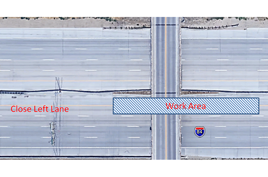
The Idaho Transportation Department has received interest regarding the traffic control plan for the Five Mile to Orchard project on Interstate 84. You can see the entire traffic control plan for project by clicking here.
ITD Construction projects that have shoulder or lane restrictions are required to include a traffic control plan that meet the standards included in the federal and state approved Manual on Uniform Traffic Control Devices (MUTCD). These contractor traffic control plans are used to set up signs, barrels, and other traffic control devices for a project.
Below is a brief description of the traffic control plan:
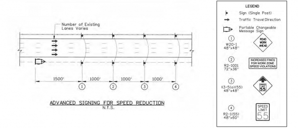
First, the plans for advance warning signs before the lane reduction. This information can be found on page 14 of the traffic control plan.
A section of the traffic control plan for warning signs before the lane closure and construction
The first sign a motorist would encounter is a portable changeable message sign on the right shoulder. This sign read “NIGHT WORK THRU JUNE: CHECK 511.” This sign was placed on the east side of the Eagle Road Overpass.
A minimum of 1,500 feet after the portable changeable message sign, the plan calls for a 4’x4’ orange diamond signs on both shoulders that read “ROAD WORK AHEAD.”
A minimum of 1,000 feet after the “ROAD WORK AHEAD” sign the plan calls for a 6’x3’ white rectangular signs on both shoulders that read “INCREASED FINES FOR WORK ZONE SPEED VIOLATIONS.” Following these signs, a minimum of 1000’ away 4’x4’ orange diamond signs on each shoulder are placed with a “SPEED LIMIT 55” box and arrow pointing up indicating a speed limit reduction ahead.
A minimum of 1,000’ feet beyond these orange diamond sign, the plan calls for 4’x5’ white and black rectangular signs on both shoulders reading “SPEED LIMIT 55.” At this point, drivers have seen four signs on each shoulder over a minimum of 4,500 feet. All of this signage is placed before the lane restriction begins.
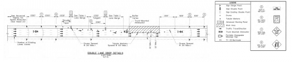
The next section ITD highlights is the beginning of the construction zone. This information can be found on page 12 of the traffic control plan.
A section of the traffic control plan showing the placement for signs and barrels before, through, and after the construction zone
A minimum of 1,000 feet after the “SPEED LIMIT 55” signs discussed above, the plan calls for 4’x4’ orange diamond signs on both shoulders indicating the number of lanes closed ahead. This project closed the three left lanes and the signs at this location on the field read “3 LANES CLOSED AHEAD.”
A minimum of 1,500 feet after these signs, the plan calls for 4’x4’ orange diamond signs on both shoulders indicating the left lane is closing ahead (sign 8 in the figure above). A minimum of 1,000’ after this sign, the taper to close off the lane begins.
The plan allows for two options on how to execute a taper. One option is to have a continuous taper closing all three lanes over 1,980 feet. The second is to have three separate tapers, with a tangent (straight) section between each taper.
The plan for this option is detailed as follows. At the beginning of each taper, an illuminated merge right arrow sign is placed. Orange drums with retroreflective lines are used for each taper and tangent section, spaced no more than 55 feet apart.
Each taper must extend a minimum of 660 feet. At the end of each taper, a minimum straight segment (identified as tangent on the plan sheets) of 1,320 feet (1/4 mile) extends until the beginning of the next taper.
Overall, from the first notice of construction at the portable changeable message sign to the final single lane of travel, a vehicle traveling the maximum legal speed would have more than two minutes and twenty seconds to make the appropriate maneuvers and be in the proper lane.