Project Update
The Idaho Transportation Department has finalized the Preferred Concept for long-term improvements to US-95 from Dufort Road to Lakeshore Drive. Based on years of study and public input, this concept is now ITD’s Proposed Action as the project enters its next phase.
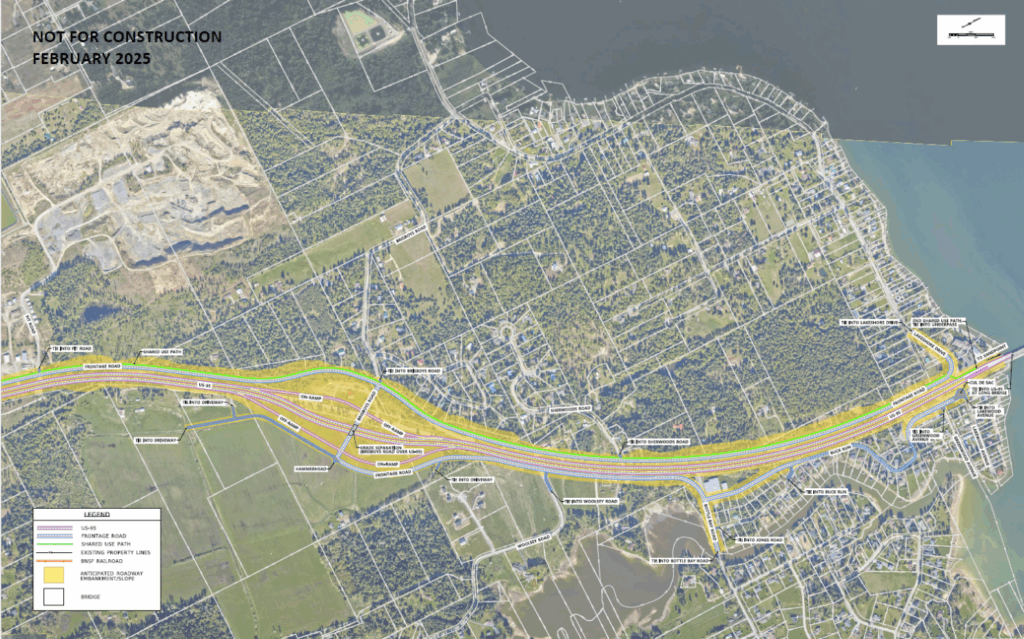
Key updates from the October 2024 public comment period include relocating the underpass from Algoma Spur/Ivy Road to Sagle Road and adjustments to the frontage road network, especially near the new Sagle underpass.
Overview
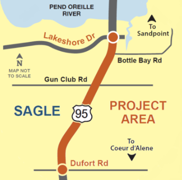
The Idaho Transportation Department is in a planning process to confirm future improvements to US-95 from Dufort Road to Lakeshore Drive.
While previous studies have resulted in many improvements along US-95, growth, congestion, and safety concerns in the area between Sagle and the Long Bridge have prompted ITD to revisit needed improvements to US-95 from Dufort Road to Lakeshore Drive.
Proposed Action overview
The Proposed Action for US-95 from Dufort Road to Lakeshore Drive is a four-lane divided highway, designed to improve safety, mobility, and long-term functionality in the region. A visualization of the Proposed Action is available for reference; please note that this rendering is conceptual and intended for illustration purposes only.
Key features of the Proposed Action include:
- Two new interchanges located at Dufort Road and Brisboys Road
- 12-foot travel lanes with 10-foot shoulders and a center median
- Two underpasses at Monarch Road/North Gun Club Road and Sagle Road
- Please note: the southern underpass has been relocated from Algoma Spur/Ivy Road to Sagle Road based on public feedback
- A frontage road network on both sides of US-95
- A shared-use pathway to accommodate pedestrians and cyclists
The frontage road network is designed to maintain access to key locations. Click the links below to watch a video of travel routes to and from each key location.
This design reflects input from community members, updated engineering studies, and environmental analysis, all aimed at building a safer and more efficient US-95 corridor.
Computer generated flyover video of the Proposed Concept
Visualizing the Corridor: Three-part map series
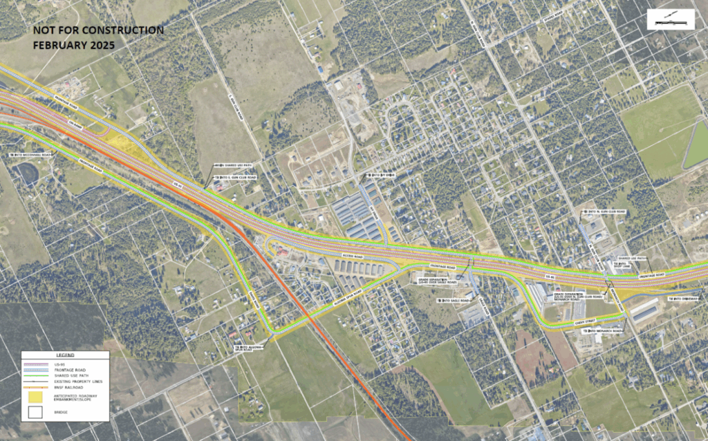
To help visualize the full project corridor, the map has been divided into three segments. Each map below highlights a specific portion of the study area, including key roads and landmarks. Please note that the middle segment – from Ivy Drive/Algoma Spur Road to Monarch Road/North Gun Club Road – includes some recent modifications stemming from the fall 2024 public meeting.
1. Dufort Road to Algoma Lake/Heath Lake Road
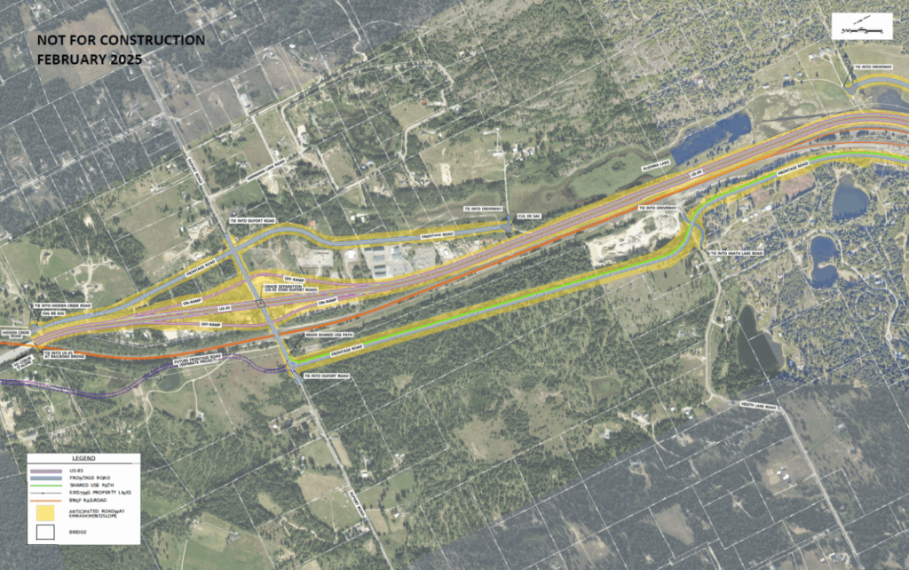
2. Ivy Drive/Algoma Spur Road to Monarch Road/North Gun Club Road
3. Pit Road to Lakeshore Drive/Lakewood Avenue
Background
In the early 2000s, ITD completed two complex environmental documents for US-95 in northern Idaho.
- US-95 Sandpoint North and South Environmental Impact Statement (1999) and Environmental Assessment (2005)
- US-95 Garwood to Sagle Environmental Impact Statement (2010)
Both studies included part of the US-95 Dufort Road to Lakeshore Drive project area. They identified future needs and potential improvements to US-95. They also identified how highway improvements could impact the environment.
Over the past 20 years, these documents have resulted in many improvements to US-95, including:
- Widening US-95 to five lanes through Sagle.
- Adding a traffic signal at the intersection of Sagle Drive and US-95.
- Adding a U-turn between Lakeshore Drive and Bottle Bay Road on US-95.
Community involvement
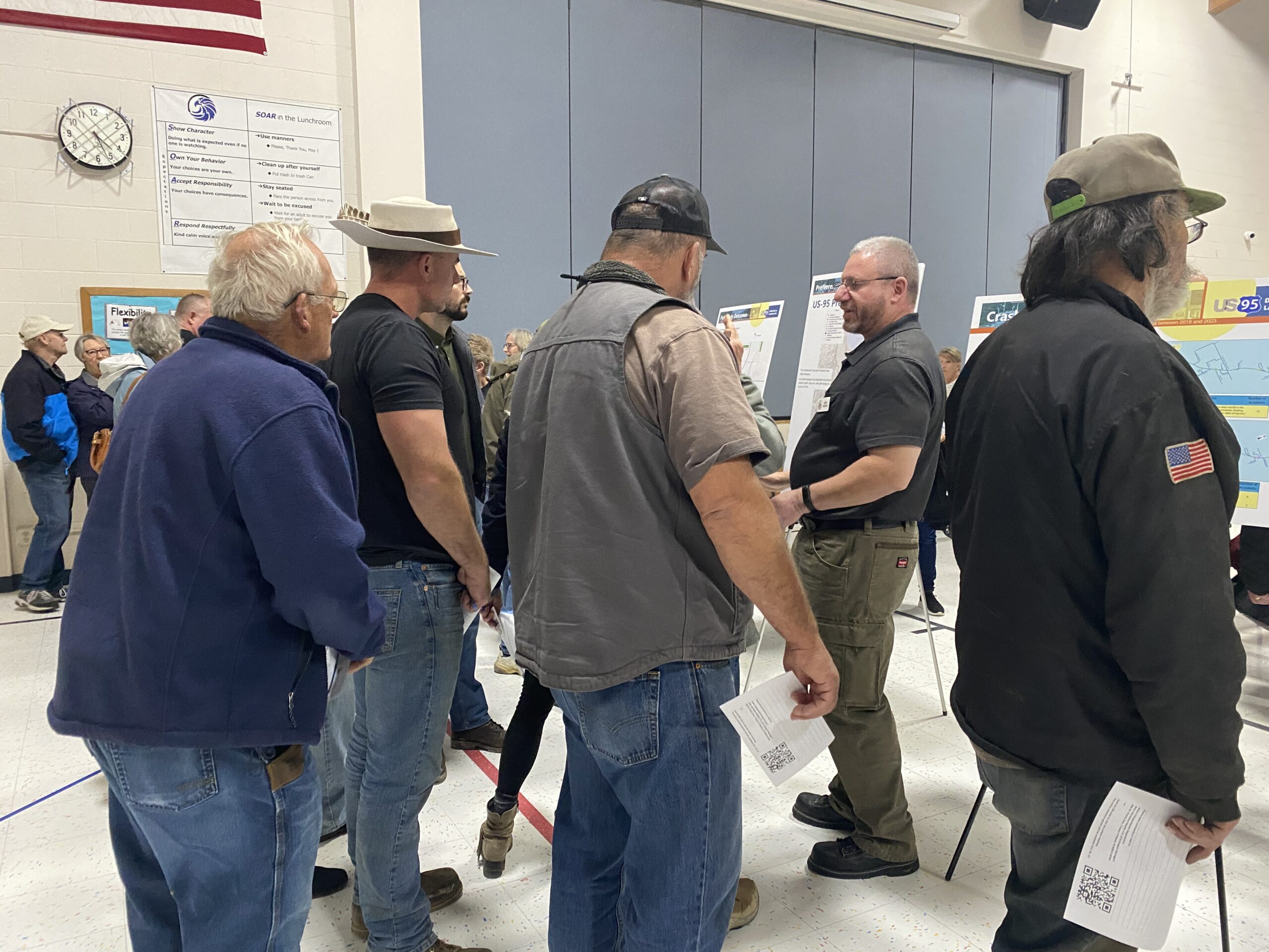
Community involvement is important to the Idaho Transportation Department and to the success of this project.
ITD would like to thank everyone who has participated in this project. Community input played a key role in the development of the Proposed Action. As the project moves forward ITD will continue to involve and update the community.
Previous Public Meetings
-
Information that was presented to the public through both an in-person and online meeting in 2023.
-
Information that was presented to the public through both an in-person and online meeting in 2024.
Next steps
The Idaho Transportation Department has finalized the Proposed Action for this project. Both the environmental re-evaluation process and preliminary design plans for the Proposed Action will be complete in 2026.
ITD anticipates this project will be constructed in multiple phases. Each phase will take time to finalize the design and to acquire the necessary right of way for the expansion of the highway. Information regarding the land acquisition process for potentially affected property owners can be found at Right of Way.
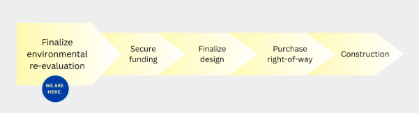
Currently, funding is not identified for the final design and construction of this project. ITD will have more information about the project timeline as the process continues.
Timeline
-
1999
US-95 Sandpoint North and South Environmental Impact Statement completed with Record of Decision
-
2010
US-95 Garwood to Sagle Environmental Impact Statement completed with Record of Decision
-
2011-2019
ITD constructed numerous multi-year projects:
- Widened US-95 to five lanes through Sagle
- Added a traffic signal at Sagle Drive and US-95
- Added a U-turn between Lakeshore Drive and Bottle Bay Road on US-95
-
2020
- Begin planning process
- Update existing conditions
- Early environmental and engineering data
- Developed Preferred Concept
-
Fall 2023-Fall 2024
- Hosted public open house to present the Preferred Concept
- Refined Preferred Concept based on community input and additional engineering work
-
Fall 2024
- Hosted a public meeting to present the updated Preferred Concept
- Gathered input and feedback from the community
-
Early 2025
- Confirmed the Proposed Action
- Continue environmental re-evaluation
-
2026
- Complete preliminary design
- Complete environmental re-evaluation
-
Future
- Secure funding
- Finalize design
- Purchase right of way
- Begin construction
Frequently Asked Questions
In the long term, and with the understanding that expansion of the US-95 corridor through Sagle will likely happen prior to expansion or replacement of the Long Bridge, ITD knows that it will be important to address the transition from 4 lanes to 2 lanes at the northern end of the project area. In response to an overwhelming amount of feedback regarding potential congestion on the bridge through the public comment period, ITD has recently approved funding to study replacement options for the Long Bridge. The study will begin in 2025 and is aimed at positioning department to be eligible for grant funding to complete the study and move into preliminary design.
This was one of the primary concerns we heard from the community about this project. Lane transitions are a common feature in transportation design both locally and nationwide. There are many areas along US-95, even currently in Sagle, where vehicles successfully transition from four lanes to two lanes without significant disruptions to the flow of traffic. This is accomplished by providing adequate merging space and appropriate signage to make drivers aware of an upcoming reduction in lanes.
Additional information regarding costs and staging will be identified later in the process, but an initial estimate for reconstructing the northbound half of the proposed structure – including bike and pedestrian facilities- will likely be at least $200 million. This study and potential future projects will be separate from this US-95 Dufort Road to Lakeshore Drive re-evaluation.
It is important to understand that this project is not being built for present day traffic volumes. By 2045, projections estimate that traffic will increase by 64% in the project area.
Over the next several years until this project can be completed, ITD is open to considering selective, cost-effective short-term improvements to address immediate safety issues. However, simply widening the roadway and adding turn lanes is not a viable, long-term solution to combat increasing vehicle volumes and congestion through the Sagle corridor.
Adding width and turn lanes does not address the numerous side street accesses and approaches that pose a safety concern for vehicles attempting to access US-95, especially for left turning vehicles.
Until ITD can construct the long-term vision for this corridor, we are evaluating other potential interim improvements that could help improve safety and congestion issues in the near future.
Yes, ITD has considered adding signals to this corridor; however, those additions won’t meet the long-term needs of safety and mobility for US-95. The traffic signal at Sagle Road installed in 2023 was built as an interim safety solution in anticipation of this study, as will be any additional signals that might be added in the future prior to expansion of US-95. Signals added wont’ be permanent once the preferred concept is fully constructed.
As the primary route through the state and into Canada, keeping traffic free flowing supports critical commerce activities. Investing in interchanges, rather than signals, will support the economy and provide safer access to the highway. Conversely, the addition of traffic signals would slow mobility and actually increase the likelihood of crashes and minor incidents when compared with the safety projections for a divided, controlled access freeway.
While roundabouts can allow traffic to flow more freely than signals, they are more difficult for the 2,400 commercial vehicles that travel US-95 each day to navigate. Considering the safety interests of non-motorized users, including pedestrians and cyclists, it also makes roundabouts a difficult option because of the continuous flow of traffic.
Under the current concept design, we have the opportunity to place frontage roads which will separate local traffic from the high-speed highway traffic to improve both safety and mobility, which is the preferred solution and meets the long-range vision for functionality of US-95.
As documented in the original environmental impact statements, the purpose of this project is to support the overall goal of accommodating present and future traffic demands and improving the safety of the existing highway for all users. The way we accomplish this is to upgrade the two-lane highway to a four-lane divided freeway with full access control, which will allow for higher speeds.
US-95 is a federal highway and a designated truck route from the Canadian border to the southern United States. This project is being designed as a controlled access, high-speed arterial in keeping with this vision. Currently there are sections now that are 45mph but once the highway is expanded to a divided lane, controlled access facility the frontage roads will serve as the direct access to businesses and residences and they will operate at reduced speed limits.
In the time between now and when this project is fully completed, there may be temporary steps taken to help address safety and congestion issues throughout the corridor which may include speed limit adjustments, however there is no guarantee that reducing the speed limit will resolve either of those issues.
Often times people suggest that simply lowering the speed limit along a particular section of roadway will result in safer driving conditions, but research has shown that is not necessarily true. Reducing the limit below the warranted speed can actually be hazardous by creating extreme variances between speeds of individual vehicles traveling on the highway. When determining speed limits, engineers attempt to set a limit that is warranted by the geographical and safety constraints of the physical roadway itself, and is also within a realistic range for the expectations for a majority of drivers. This encourages compliance with the limits and laws, is reasonably enforced, and minimizes speed variations between vehicles at any given time.
A reliable frontage road network will provide safe, efficient, and effective connectivity to all residences & businesses within the project corridor. They will greatly reduce the need for local traffic to access the highway for local point-to-point travel.
Frontage roads will eliminate all cross-traffic on US-95 by providing local access to destinations which will increase safety for all users and allow for more efficient mobility on mainline US-95 by eliminating conflict points and supporting higher speeds.
This frontage road network will generally parallel US-95 and provide east/west connectivity through the use of underpasses at Sagle Road and Monarch or North Gun Club Road. Because the frontage roads will be constructed at the existing grade, US-95 will rise up and over the roadway in certain locations to accommodate traffic beneath.
An effective frontage road network also means that it will be safer, easier and faster for first responders to reach people in the event of an emergency.
Projects such as the expansion of the US-95 corridor from Dufort Road to Lakeshore Drive typically go through evaluation, design and construction over several years. At the present time, ITD does not anticipate construction of the Proposed Action for approximately 10 to 15 years unless funding becomes available.
The scope of the proposed changes will result in multiple phased projects that each will take time to finalize the design and negotiate with landowners to buy the necessary right of way for the expansion of the highway. Information regarding the land acquisition process for potentially affected property owners can be found on the Idaho Transportation Department website.
Currently, funding is not identified for the final design and construction of this project. ITD will have more information about the project timeline as the process continues
Public feedback is a critical part of developing transportation projects and infrastructure across the state. ITD encourages members of the community to remain engaged with this project as it progresses through the re-evaluation phase, into design, and ultimately, into construction.
Anyone interested in updates as this project progresses can find updated information on this project website, subscribe for email updates, and attend upcoming open house events either in person, or online.
Downloads and Resources
Contact the project team
For questions or comments about this project, please contact the project team at info@us95duforttolakeshore.org or (208) 243-9326.