

Overview
The Idaho Transportation Department (ITD) has begun a project to evaluate the Blue Lakes Boulevard and Pole Line Road intersection and surrounding roadway system.
The purpose of the project is to identify improvements that improve mobility and safety at the intersection. We welcome your comments and invite you to follow along with project updates. Provide feedback to the project team and sign up for project updates using the button below.
Provide Comments and Sign Up for Updates
Project Background
The Blue Lakes Boulevard and Pole Line Road intersection serves as a gateway intersection into the City of Twin Falls for vehicles, both passenger vehicles and heavy freight, traveling from I-84 and across the Perrine Bridge just north of the intersection. Today, this intersection is one of the busiest in the area and experiences high levels of congestion. Conditions are anticipated to worsen as the area continues to grow.

Project Study Area
The study area includes 7 signalized intersections,13 unsignalized intersections, and over 50 commercial driveways and accesses.
- Northern limit on US-93 is Golf Course Road
- Southern limit on Blue Lakes Boulevard is Falls Avenue
- Western limit on Pole Line Road is approximately 1000 feet west of Fillmore Street
- Eastern limit on Pole Line Road is east of Bridgeview Boulevard

Project Overview
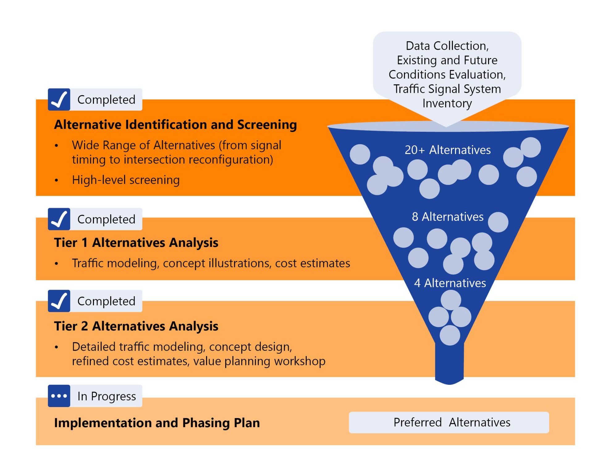
The goal of the study is to identify improvements for the Blue Lakes Boulevard and Pole Line Road intersection and surrounding area that may be implemented in the short, medium, or long term. The improvements will aim to improve both safety and traffic congestion. This study will identify improvements through a tiered alternatives evaluation, as shown in the graphic below.
We are engaging with partner agencies, stakeholders, business and property owners, and the public to better understand the needs and challenges within the study area and work collaboratively to identify improvements.
The study began in Fall of 2025 with the evaluation of existing and future no-build conditions. In February 2026, the project team met with the Business and Property Owners Advisory Group to introduce the project’s background and purpose. During the meeting, the project team shared results of the existing and future no-build evaluation and gathered feedback on transportation deficiencies and concerns that exist within the study area today. Using this feedback, along with feedback from partner agencies and stakeholders, the project team has evaluated over 20 alternatives through a tiered alternatives analysis.
The final stage of this alternatives analysis, the Tier 2 Alternatives Analysis, was completed in August 2026. The results of this evaluation was presented to the Technical Advisory Group, Project Advisory Group, and Business and Property Owners Advisory Group in September 2026 and resulted in the selection of a preferred alternative. The next stage of the project will include refinements to the preferred alternative, development of an implementation and phasing plan, and a public open house. The project is anticipated to be completed in early 2027. There are currently no funds dedicated to design and construct the alternatives identified as part of this project.
Downloads & Resources
Technical Memo # 1
Existing & Future No Build Memorandum (FINAL).pdf
Existing & Future No Build Memorandum (FINAL)_Attachments.pdf
Business and Property Owner Advisory Group Meeting #1 – February 2026
Business Property Owner Advisory Group Meeting 1_Display Boards.pdf
Business Property Owner Advisory Group Meeting 1_Summary.pdf
Technical Memo # 2
Tier 1 Alternatives Evaluation (FINAL).pdf
Tier 1 Alternatives Evaluation (FINAL)_Attachments.pdf
Tier 1 Alternatives Moving to Tier 2 Evaluation.pdf
Business and Property Owner Advisory Group Meeting #2 – September 2026
Business Property Owner Advisory Group Meeting 2_Display Boards
Business Property Owner Advisory Group Meeting 2_Summary.pdf
Technical Memo # 3
Tier 2 Alternatives Evaluation (FINAL).pdf
Tier 2 Alternatives Evaluation (FINAL)_Attachments.pdf
Tier 2 Alternatives_Concept Designs.pdf
How to Participate
Project Website – This project website will be updated periodically throughout the project as key project milestones are completed.
Public Open House – A community open house will be held following the selection of the preferred alternatives to share the chosen designs and discuss next steps for the project. It is anticipated that the community open house will be held in early-2027.
Business and Property Owner Advisory Group – The project team is holding group meetings and one-on-one meetings with Business and Property Owner Advisory Group members. The Business and Property Owner Advisory Group consists of representatives from businesses and properties within the study area. The purpose of the group is to help identify and discuss traffic-related challenges, including access to and from businesses in the surrounding area, and provide feedback on proposed alternatives. As of October 2026, the project team has held two group meetings with the Business and Property Owner Advisory Group and one-on-one meetings with individual representatives. Additional group and one-on-one meetings will be held on an as-needed basis for the remainder of the project.
Provide Feedback and Sign-Up Updates – Provide comments and stay informed by signing up for updates below.
Provide Comments and Sign Up for Updates
Contacts
Brock Dillé
ITD Project Manager
brock.dille@itd.idaho.gov
208.544.7906
Mark Heisinger
Consultant Project Manager
mheisinger@kittelson.com
208.472.9820
Andy Daleiden
Consultant Project Principal
adaleiden@kittelson.com
208.472.9804